没有合适的资源?快使用搜索试试~ 我知道了~
温馨提示
试读
15页
在本文中,我们将进行案例研究,将经过精炼的3D储层地质模型,井网试点测试和实时GeoSteering工具集成在一起,以优化粘性油藏的生产性能。 粘性储量具有较高的结构倾角。 此外,三角洲沉积系统代表了高度变化的地貌,堆积的砂体和页岩层理经常相交。 为了保持较高的生产率,仅使用水平井和注水是不够的。 因此,详细的储层特征描述,井网先导实验和GeoSteering被用于优化先前的开发策略,并使水平轨迹安全地降落到储层目标区。 从地震解释中得出的地层层序构造非常有效地捕捉了这些高倾角构造背景下的变化。 选择的最佳组合是“从OWC外部注入水”和“楼梯形水平轨迹”。 然后,在轨迹着陆过程中,通过GeoSteering工具成功地分析和控制了这些优化策略的井眼碰撞风险。 这些更新的开发策略极大地提高了油藏开发性能。
资源推荐
资源详情
资源评论
Open Journal of Geology, 2018, 8, 859-873
http://www.scirp.org/journal/ojg
ISSN Online: 2161-7589
ISSN Print: 2161-7570
DOI:
10.4236/ojg.2018.89050 Aug. 6, 2018 859 Open Journal of Geology
Integrating Geology and Engineering for
Viscous Oil Production Improvement
—JX Oilfield, Bohai Bay, China
Zhicheng Yang
*
, Yunpeng Li, Zongbin Liu, Gaige Wang, Qi Cheng
JX Oilfield, Bohai Bay, Tianjin, China
Abstract
In this paper a case study is presented where refined 3D reservoir geology
models, well pattern pilot test and Real-time GeoSteering tools have been in-
tegrated to optimize production performance of a viscous oil reserve. The
viscous reserves were of high structural dip angle. In addition delta deposi-
tional system represented highly variable geomorphology, where stacked
sandbodies and shale bedding are crossing each other frequently. In order to
keep a higher production rate, using horizontal wells along with water injec-
tion was not enough; therefore, detailed reservoir characterization, well pat-
tern pilot experiment and GeoSteering were used to optimize previous de-
velopment strategy and keep horizontal trajectories safely landing into reser-
voir target zone. The stratigraphic sequence architecture that is derived from
seismic interpretations captured the variation within these high dip structural
backgrounds very effectively. The best combination of choices was “Injecting
Water outside from OWC” and “Stair Sha
ped Horizontal Trajectories”. The
borehole collision risks of these optimized strategies
were then analyzed and
controlled successfully by the GeoSteering
tools during trajectory landing
process. The reservoir development performance is improved tremendous
ly
as result of these renewed development strategies.
Keywords
High Viscosity Oil Development, Integration of Geology a
nd Engineering,
Horizontal Well Development, GeoSteering, Improvement of Recovery Efficiency
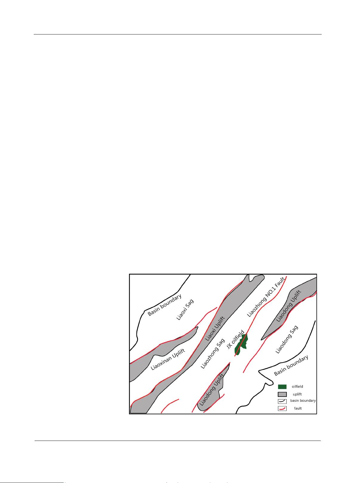
1. Introduction
The study area comprises of an oil field where 4 wells have been drilled in the
second and third member of the DongYing (Ed2~3). These wells drilled were
targeting the conventional front delta deposits within this strike slip basin. Well
How to cite this paper:
Yang, Z.C., Li,
Y
.P., Liu, Z.B., Wang, G.G. and Cheng, Q
.
(201
8) Integrating Geology and Engineer-
ing for Viscous Oil Production Improv
e-
ment
—JX Oilfield, Bohai Bay, China.
Open
Journal of Geology
,
8
, 859-873.
https://doi.org/10.4236/ojg.2018.89050
Received:
July 11, 2018
Accepted:
August 3, 2018
Published:
August 6, 2018
Copyright © 201
8 by authors and
Scientific
Research Publishing Inc.
This work
is licensed under the Creative
Commons Attribution International
License (CC BY
4.0).
http://creativecommons.org/licenses/by/4.0/
Open Access
Z. C. Yang et al.
DOI:
10.4236/ojg.2018.89050 860 Open Journal of Geology
JX-1 was drilled in 1998 which was the first deep well targeting the reservoir; the
well encountered several different reservoir sands in the upper section. Hori-
zontal Well JX-X was drilled in 2000, targeting the reservoir. The results of both
the wells were very similar, which showed that the Lower Unit is comprised of
thick sand which contains several different sand units ranging from 5 to 10 m
thickness. The spreading length of these sand bodies (400 - 500 m) is too narrow
to be well controlled with this kind of well pattern.
The production results of wells were not exceptionally well, and both wells
flowed 9.5 and 9.2 m/d after which the wells depleted rapidly. Well B was drilled
only 300 m away from Well A, but to surprise this well encountered only frac-
tions of sand units in the Upper Unit where the thickness of sand bodies was
only 2 to 5 meters much less as compared to sand thickness in Well A and B. As
a result of this complex reservoir in terms of production behavior and indica-
tions of a complex depositional environment and steep structural background in
this paper, a geological reservoir engineering integrated workflow was adopted
along with detailed working one horizontal trajectories design to understand the
full potential of this field and to determine the best location for the next devel-
opment wells.
JX Oilfield is located in middle area of Liao sag, China Bohai Bay (
Figure 1).
The average water depth is 29 m. Because of Tan-Lu slip faults system, it is di-
vided into east and west parts by No.1 LiaoZhong Major fault. Furthermore, it is
made up with many fault blocks which are controlled by associated faults. Con-
trolled by this giant slip fault, western part is a simple anticline, but the eastern
one is a complicated fault block trap. Both parts have a similar average dip angle
between 8˚ to 15˚.
Figure 1. Location map of JX oilfield and regional structural background, target block is
in south-west corner 5 block.
Z. C. Yang et al.
DOI:
10.4236/ojg.2018.89050 861 Open Journal of Geology
Reservoir was formed during DongYin Period; sedimentary environment is
consisted of meandering and braid delta. The total reservoir thickness is thick,
but is separated in regular spacing shaly layers. In a map view, the reservoir
shows a strip distribution pattern with width between 280 - 700 m. It is a typical
clastic rock consisting mid-fine and feldspar debris sand, low ingredient mature,
average content of quartz is 37.2%, feldspar is 39%, debris is 23.8%. Oil viscosity
is ranging between 248.00 ~ 262.00 mPa∙s, Formation 2 average pososity is
29.6%, permeability 1431.3 mD, and Formation 3 average pososity is 26.8%,
permeability 893.3 mD. In general, it is a premium reservoir with high porosity
and permeability but high fluid viscosity.
JX Oilfield is located in Tan-Lu slip fault band. The reservoirs have been dis-
covered on each side of the slip fault band. West block has a lot of associated
faults and strata dip is between 8˚ ~ 15˚. It is considered as layer structural trap
and without a unify OWC. The maximum thickness of reservoir is 193 m with 8
sets of water-oil system, oil viscosity is ranging from 248 to 262 mPa∙s. It is very
difficult to make a comprehensive field development strategy for this oilfield
with narrow oil area and multiple target zones. As a result, calibrated EOR only
achieves 19.6% since first ODP has been executed 2008.
The dataset for this study is summarized below:
1) 30 sq·km of 3D seismic.
2) Openhole common logs and petrophysical analysis.
3) Production history of all wells.
2. Objectives
In order to further improve the understanding of the reservoir and reduce the
risk of drilling, the project team has developed research objectives. The objec-
tives of this study are summarized below:
1) To determine the stratigraphic sequence architecture of Dong 2-3 mem-
bers.
2) To map the distribution channels and mouth bars based on seismic
attributes and inverted impedence and to distinguish between reservoir to
non-reservoir.
3) To build up a static 3D model based on the existing data which strongly in-
tegrates the dimensions of the sand bodies.
4) To choose one plan from different well optimized patterns according to the
3D model forecasting simulation results.
5) To design “stair shaped” horizontal trajectories with this 3D model.
6) To update geology understanding after optimized wells being drilled.
3. Challenge
3.1. Challenge 1, Complex Structure and Reservoir Heterogeneity
Complex slip fault background. Previous researches proved that the complex
fault structural was controlled by slip faults band (
Figure 2). There is an apparent
剩余14页未读,继续阅读
资源评论
weixin_38722184
- 粉丝: 5
- 资源: 899
上传资源 快速赚钱
- 我的内容管理 展开
- 我的资源 快来上传第一个资源
- 我的收益 登录查看自己的收益
- 我的积分 登录查看自己的积分
- 我的C币 登录后查看C币余额
- 我的收藏
- 我的下载
- 下载帮助
安全验证
文档复制为VIP权益,开通VIP直接复制
信息提交成功