没有合适的资源?快使用搜索试试~ 我知道了~
Deltas of the Lake Malawi Rift, East Africa_ Seismic Expression
需积分: 5 0 下载量 188 浏览量
2023-07-09
19:41:58
上传
评论
收藏 1.86MB PDF 举报
温馨提示
试读
19页
Deltas of the Lake Malawi Rift, East Africa_ Seismic Expression and Exploration Implications
资源推荐
资源详情
资源评论
ABSTRACT
High-resolution, air-gun–sourced seismic reflec-
tion surveys over the offshore regions of five river
deltas in Lake Malawi in the East African rift system
reveal considerable variability in acoustic facies and
stratigraphic architecture. This variability can large-
ly be attributed to the influences of different struc-
tural settings, and to a lesser degree to high-ampli-
tude (100–400 m) and high-frequency (1000 to
100,000 yr) fluctuations in lake level. Deltas on
flexural and axial margins in the rift lake show well-
developed progradational geometries. In contrast, a
delta on a steep, accommodation zone margin dis-
tributes coarse sediments over a broad depositional
apron, rather than concentrating sediment in dis-
crete progradational lobes as on the other deltas. A
large border fault margin river delta displays the
most complex tectonic and stratigraphic architec-
ture of all the deltas studied. It contains several
delta-associated facies, including prograding clino-
form packages, fan deltas stacked against a bound-
ary fault, and extensive subaqueous fans. Flexural
margin lowstand deltas may be the most prospec-
tive for hydrocarbon exploration due to their large,
internally well-organized, progradational lobes and
their close proximity to deep-water, high total
organic carbon lacustrine source facies.
INTRODUCTION
Lacustrine basins produce large quantities of oil
and gas. Although their potential for accumulating
significant volumes of source rocks is well estab-
lished (Fleet et al., 1988; Katz, 1990), models for
hydrocarbon reservoir facies in lacustrine systems
are not well developed. Many of the largest and
most productive lacustrine basins have developed
within extensional systems, including those
on the west coast of Africa (e.g., Teisserenc and
Villemin, 1989), in China (e.g., Xue and Galloway,
1993), in southeast Asia, and on the Brazilian con-
tinental margin (e.g., Abrahão and Warme, 1990).
Deltaic systems in different structural settings
within lacustrine rifts have not previously been
systematically surveyed in detail for their potential
as hydrocarbon reservoirs. This paper presents
the results of a series of high-resolution air-gun
seismic reflection surveys conducted on the mod-
ern deltas of the Lake Malawi rift, and discusses
the implications of these results for oil and gas
exploration.
The East African rift system is commonly con-
sidered the archetypical example of a continental
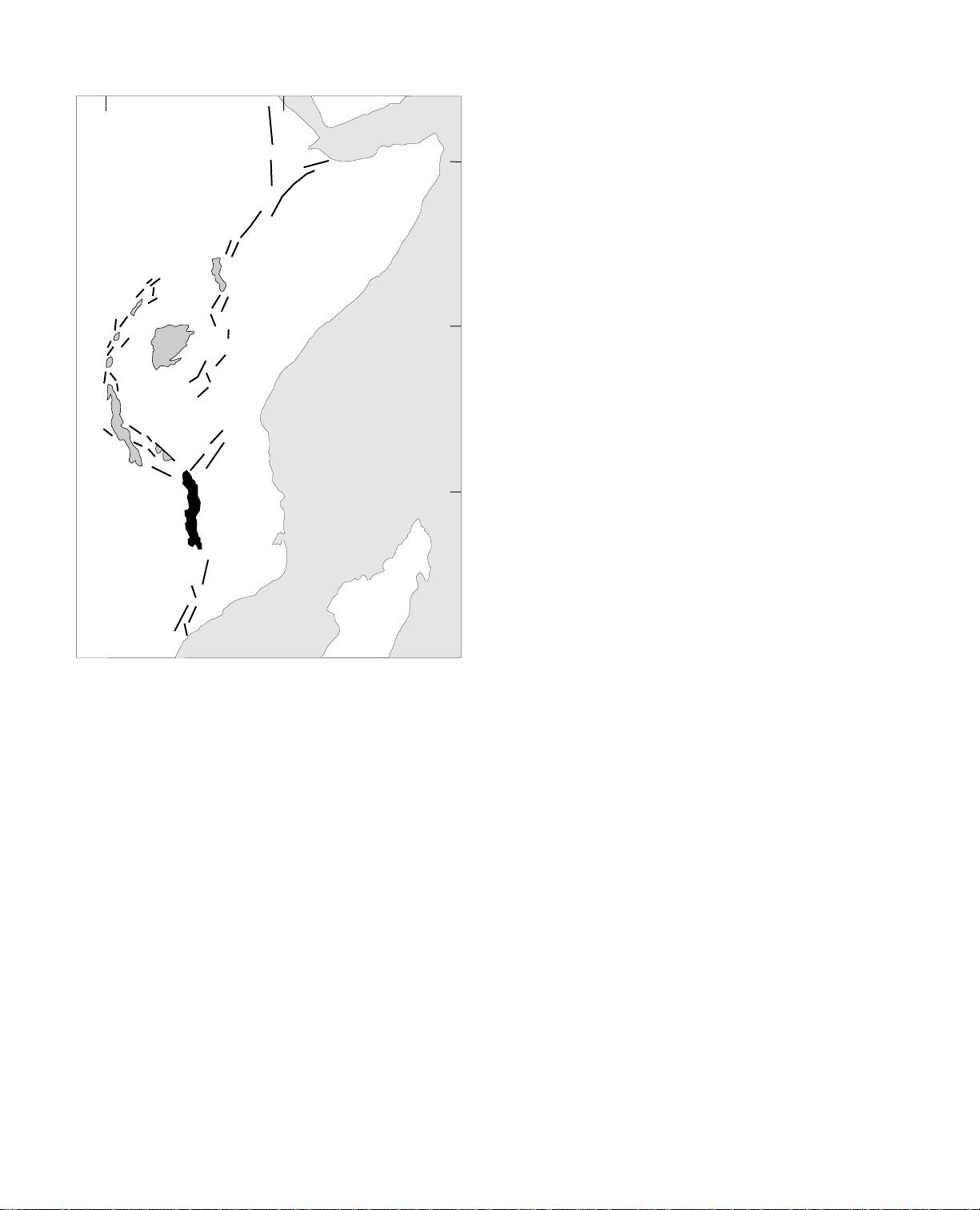
rift (e.g., Suess, 1891). Lake Malawi, also known
as Lake Nyasa, is the second largest and deepest
of the lakes that occupy the western branch of
the rift system (Figure 1). The lake extends for
about 560 km between 9°30′ and 14°25′S lati-
tude, is about 60 km wide on average, and has a
maximum water depth of just more than 700 m
(Figures 1, 2). The elevation of the lake surface is
474 m above sea level. Seven major river systems
drain into the lake, in addition to numerous small-
er drainages, and the lake’s outlet is located at the
southern end of the southeast arm (Figure 2). As
is the case with many large tropical lakes, the
water column is permanently stratified and anox-
ic below depths of 150–200 m (Eccles, 1974;
Halfman, 1993).
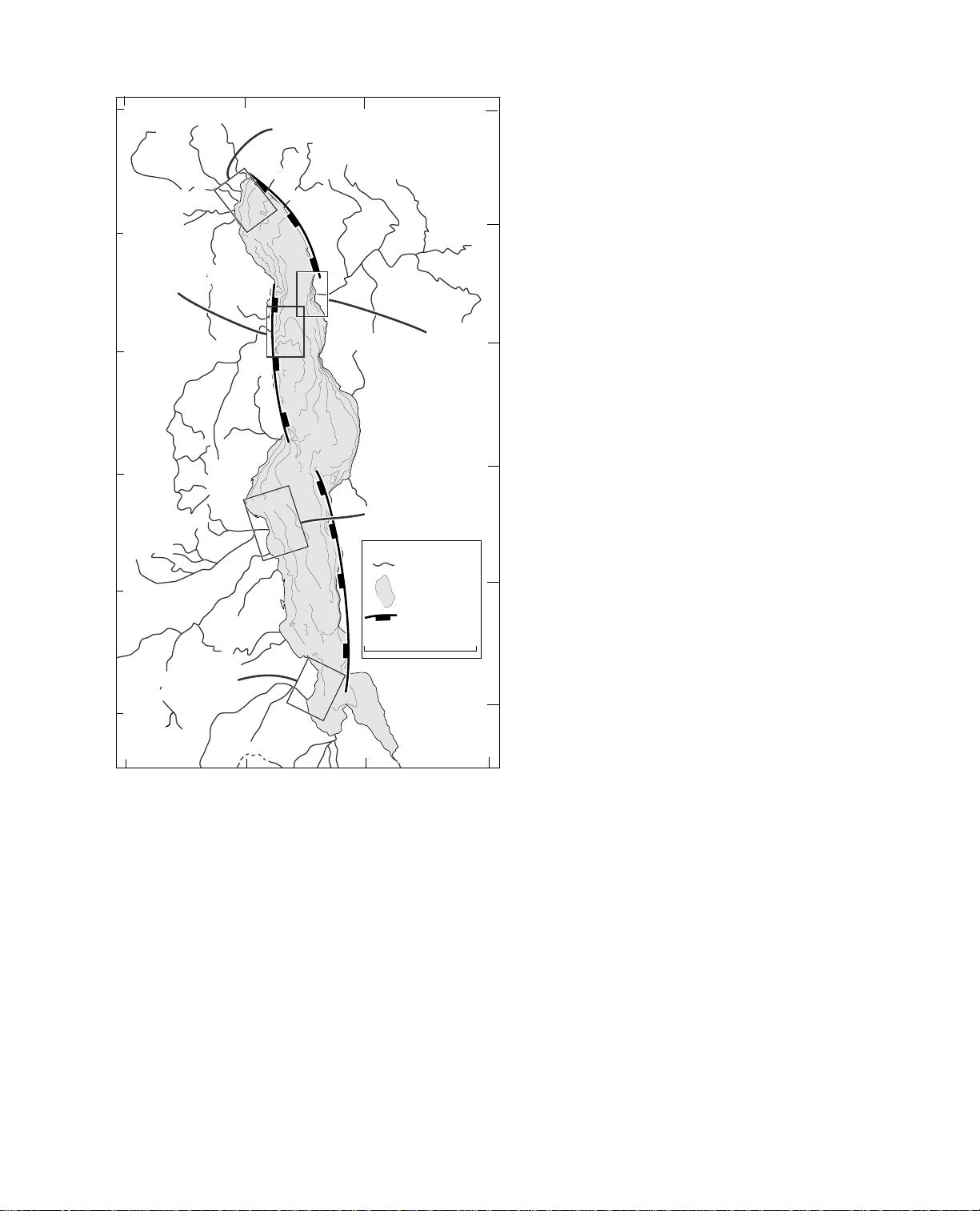
In 1992, integrated surveys were conducted
over five of Lake Malawi’s seven major river deltas.
These are each located in different structural and
climatic settings around the margin of the lake
(Figure 2). The surveys included acquisition of
1679
AAPG Bulletin, V. 79, No. 11 (November 1995), P. 1679-1697.
©Copyright 1995. The American Association of Petroleum Geologists. All
rights reserved.
1
Manuscript received December 28, 1994; revised manuscript received
May 17, 1995; final acceptance June 19, 1995.
2
Division of Marine Geology and Geophysics, Rosenstiel School of
Marine and Atmospheric Science, University of Miami, 4600 Rickenbacker
Causeway, Miami, Florida 33149.
I thank C. L. Bowland, G. P. Eberli, and T. C. Moore for providing initial
reviews of the manuscript, and M. Dolozi, T. C. Johnson, J. D. Halfman, and
J. T. Wells for numerous discussions on lacustrine deltas. J. McGill and L.
Kalindekafe provided considerable assistance during the field work. I thank
the governments of Malawi and Tanzania for permission to conduct this
research; the University of Malawi, Malawi Department of Surveys, Malawi
Geological Survey, National Research Council of Malawi, Malawi Fisheries
Research Unit–Monkey Bay, Malawi Railways, the Tanzanian Council on
Science and Technology, the Tanzanian Petroleum Development
Corporation, and the captain and crew of the
S/V Timba
for their assistance;
and P. Cattaneo, J. Cheek, and R. Gonzalez for assistance in data
processing and figure preparation. Insightful comments by
AAPG Bulletin
Elected Editor K. T. Biddle and reviewers K. Burke, T. L. Patton, and D. J.
Reynolds helped improve the manuscript. This work was supported by
Amoco, Anadarko, ARCO, British Gas, Chevron, Conoco, Exxon, Marathon,
Mobil, Petrofina, and Texaco oil companies.
Deltas of the Lake Malawi Rift, East Africa: Seismic
Expression and Exploration Implications
1
Christopher A. Scholz
2
2400 km of single-channel digital air-gun seismic
reflection data, comparable amounts of 1 kHz
high-resolution seismic reflection and side-scan
sonar data, and 90 sediment cores from both
onshore and offshore parts of the deltas. Here I
focus on the results of the air-gun surveys;
details of core analyses, 1 kHz high-resolution
seismic data, and side-scan sonar data are pre-
sented in companion publications (Wells et al.,
1994; Johnson et al., 1995). The air-gun seismic
data set illustrates the marked differences in
structural and stratigraphic architecture
between the deltas, and permits observations
about delta process variability between different
structural settings. The conclusions drawn here
should enable explorationists working in
prospective lacustrine rift basins to prioritize
their efforts according to specific tectonic and
stratigraphic settings.
TECTONIC FRAMEWORK AND CLIMATIC
SETTING
The East African rift system is comprised of a
series of half-graben basins that are linked end-to-
end along the axis of the rift (Rosendahl et al.,
1986; Rosendahl, 1987). Each of the individual half
grabens has consistent dimensions, averaging
about 120 km long and 70 km wide. In many
instances, adjacent half-graben basins alternate dip
polarity, and the linkage zones between basins are
commonly referred to as accommodation or trans-
fer zones, which are structurally varied and com-
plex (Reynolds and Rosendahl, 1984; Rosendahl,
1987; Morley et al., 1990). In this paper, I use the
term “accommodation zone” to refer to the large-
scale features separating primary half-graben
basins.
The Malawi rift zone is composed of three main
half grabens, or dip domains, and several smaller
basins (Ebinger et al., 1987; Specht and Rosendahl,
1989) (Figure 2). Each half-graben basin is bounded
on one side by a relatively steep (~65°), planar bor-
der fault, and on the opposite side by a flexural,
hanging-wall or shoaling margin. Intrabasinal faults
generally strike parallel to the rift axis. High rift
mountains commonly form the footwall of the bor-
der faults on the lake shoreline. In the case of the
Livingstone basin in northern Lake Malawi, the
Livingstone Mountains rise more than 1500 m
above the adjacent lake surface. Offshore deposi-
tional slopes on the border fault side of the rift are
steep, typically 6° or more, whereas those of the
flexural margin are considerably lower, about 1° or
less (Scholz et al., 1993).
Multichannel seismic surveys conducted during
the 1980s revealed that the lake is underlain by
upwards of 4–5 km of synrift lacustrine sediments
(Flannery, 1988; Specht and Rosendahl, 1989). The
thickest accumulations are found in the far north,
and generally decrease toward the southern tip of
the lake where only a few hundred meters of syn-
rift fill are imaged. This progression suggests that
rifting has propagated from north to south
(Flannery, 1988). The greater subsidence and water
depths, and higher onshore relief in the north com-
pared to the south, have produced strong contrasts
in the style of basinal sedimentation (e.g., Johnson
and Ng’ang’a, 1990; Scott et al., 1991).
Bedrock geology is quite variable around the rift
valley, and includes Precambrian meta-sediments
and meta-igneous rocks, Permian–Triassic Karroo
sedimentary rocks, Cretaceous red beds, Pliocene
and younger lacustrine sediments, as well as early-
middle Paleozoic plutonic rocks (Malawi Depart-
ment of Surveys, 1983). There are significant dif-
ferences in bedrock geology between drainage
basins.
1680 Lake Malawi Rift, East Africa
30°
40° E
10° N
10° S
0°
Lake
Malawi
Indian
Ocean
Lake
Tanganyika
Lake
Rukwa
Lake Turkana
Lake
Albert
East
Africa
Lake Victoria
Figure 1—East Africa showing Lake Malawi and
major faults and lakes of the East African rift system.
The large, deep lakes are located in the rift’s western
branch.
Lake Malawi is located in an area dominated by
woodland and wooded grasslands. Annual rainfall
increases from about 700 mm around the southern
arms of the lake to more than 2500 mm in the far
north. Rainfall is also generally correlated with
higher elevations (Malawi Department of Surveys,
1983). The strongest winds blow from the south-
east, particularly during the austral winter, the local
dry season. This strong prevailing wind has a pro-
nounced effect on the major river deltas in the
lake; whereas most sediment is delivered to the
delta fronts during the intense rains (December–
April), the sediments are then reworked and
redistributed over a broad area during the windy
dry season (May–August) (Wells et al., 1994).
SUBAERIAL DELTAS AND OPEN-LAKE
DEPOSITIONAL PROCESSES
Sedimentary processes in the open waters of the
lake have received considerable attention over the
past several years (e.g., Johnson and Davis, 1989;
Owen and Crossley, 1989; Johnson and Ng’ang’a
1990; Scott et al., 1991). The subaerial deltas, how-
ever, have only recently been studied in detail
(Wells et al., 1994). Each of the seven major river
systems that enter into Lake Malawi has a drainage
area greater than 7500 km
2
. Four are situated on
flexural margins of the half-graben basins. This
study examined deltas of two of those systems
belonging to the Dwangwa and Linthipe Rivers
(Figure 2). The other major deltas studied are the
Songwe, an axial margin system, the South Rukuru
system, situated on a border fault margin and the
Ruhuhu system, which enters the lake at an accom-
modation zone (Figure 2).
In general, the subaerial deltas are not of the
braid- or fan-delta type (after McPherson et al.,
1987) that is commonly associated with rift basins
and extensional systems. Rather, their relatively
flat, broad delta plains; moderate to high sinuosity;
protuberant shoreline; and reworked sandy beach
shoreline are similar to those of mixed-energy,
fluvial- to wave-dominated marine deltas such as
the Po and Brazos Rivers, particularly with respect
to discharge, subaerial extent, and drainage basin
size (Wells et al., 1994). There is evidence for high
wind and wave energy environments around most
of the deltas; large beach ridges, small dune fields,
extensive beaches, and sandy shelves are common
characteristics. Most of the subaerial deltas are rela-
tively large, between 36 and 161 km
2
; the excep-
tion is the small South Rukuru delta, which is the
only one of the five systems studied that can be
classified as a fan delta.
HISTORY OF LAKE-LEVEL CHANGE
Several lines of evidence suggest that water lev-
els in Lake Malawi and in the other East African rift
valley lakes fluctuated dramatically in the late
Quaternary. Owen et al. (1990) cite tribal oral his-
tories and present analyses of sediment cores and
hydrological models that indicate a drop of more
Scholz 1681
500
100
100
100
200
200
300
100
200
100
200
300
400
100
200
300
400
500
600
700
200
300
400
400
300
200
100
major
border faults
14°
13°
12°
11°
10°
09° S
36°E
35°34°
33°
Songwe delta
(axial margin)
Ruhuhu delta
(accommodation
zone margin)
South Rukuru delta
(border fault margin)
Dwangwa delta
(flexural margin)
Linthipe delta
(flexural margin)
Songwe River
Livingstone Mtns.
500
water
depth in meters
rivers
Legend
Kiwira River
Shire River
100 km
Figure 2—Tectonic and bathymetric map of Lake Malawi
showing three major half-graben basins of the rift and
prominent river drainages. The Shire River is the lake’s
sole outlet and flows south to the Zambezi River. Bathy-
metric contour interval is 100 m. Boxes indicate the loca-
tions of the five delta study areas. Individual seismic grids
are shown in Figure 3 (Dwangwa delta), Figure 6 (Songwe
delta), Figure 9 (South Rukuru delta), and Figure 12
(Ruhuhu delta). Linthipe delta data are not presented.
than 100 m in the level of Lake Malawi in the past
500 yr. Interannual water-level fluctuations of 2–3
m have been common over the past century.
Scholz and Rosendahl (1988) examined erosional
surfaces on multichannel seismic profiles from
Lakes Malawi and Tanganyika, and suggested that
levels were more than 250 m and 500 m lower,
respectively, in the late Pleistocene. Tiercelin et
al. (1989) identified low stages at depths of –300
and –600 m in Lake Tanganyika in the late
Pleistocene. Finney and Johnson (1991) used geo-
chemical proxies to identify a –100 m low lake
stand in Lake Malawi after 0.01 Ma. Scholz and
Finney (1994) further refined the lake-level histo-
ry of the basin by using high-resolution (1 kHz)
seismic data correlated to multichannel seismic
data and to sediment cores to identify other low
stages at –250 m prior to 0.028 Ma and –350 m at
0.078 Ma. These late Quaternary fluctuations are
thought to be a result largely of changing climatic
conditions. Lake Malawi is in a state of delicate
hydrologic balance, with about 90% of the annual
water loss occurring through evaporation; conse-
quently, subtle climatic shifts can have a dramatic
effect on water volume.
DATA ACQUISITION AND PROCESSING
More than 2400 km of single-channel digital seis-
mic reflection data were acquired offshore of the
five deltas; at least 400 km of data were collected at
each delta, in grids with line spacings of about 2
km (Figures 2, 3). Either a small (5–10-in.
3
) air gun
or (15-in.
3
) water gun was used as the seismic
source. Signals were collected with a Teledyne sin-
gle-channel streamer, recorded on MASSCOMP
computers using HIRES software, then processed
and displayed ashore using SIOSEIS processing soft-
ware. Positioning was controlled by continuous
GPS (global positioning system) navigation in
autonomous mode. Data processing involved digi-
tal frequency-domain filtering, muting, edits, and
application of a 100-ms AGC (automatic gain con-
trol) window.
In addition to the collection of the air-gun seis-
mic data, about 2000 km of 1 kHz high-resolution
seismic and side-scan sonar data were also
acquired. To calibrate the acoustic data, 90 short
(1–6-m-long) gravity cores and vibrocores were col-
lected from both onshore and offshore areas of the
deltas.
SEISMIC REFLECTION DATA
The most prominent features observed on the
seismic records are not related to present-day delta
sedimentation and river discharge, but rather to
river delta construction during major phases of low
lake levels that must have existed in the past. Thus
the seismic data reveal information not only on the
subaqueous part of the modern deltas, but also on
the subaerial parts of former lowstand deltas. The
single-channel seismic data provide considerable
information in the deeper, distal reaches of the sub-
aqueous delta; in shallower water depths the first
water-bottom multiple generally obscures the deep-
er parts of the sedimentary section. The following
sections describe how the deltas with the low-
angle offshore slopes, the flexural and axial margin
systems, generate the largest and thickest prograd-
ing delta deposits. These are recognized in seismic
data as sets of prograding clinoform reflections. In
contrast, the accommodation zone that was studied
has steep slopes, and does not concentrate sand
into prograding deposits. The large border fault
delta system studied reveals a complex and variable
seismic facies geometry.
1682 Lake Malawi Rift, East Africa
100
150
200
250
Fig.4c
Fig.4b
Fig.4a
100
150
200
250
recent river
mouth
modern
subaerial
delta
N
shelf edge
34°10' 34°15' 34°20'
12°25'12°30' 12°20' 12°15'12°35'
10 km
Figure 3—Bathymetry and air-gun seismic track lines
near the Dwangwa delta, southern Lake Malawi. Shelf
edge denotes marked drop in water depth from the
5–10-m-deep shelf. Contour interval is 50 m. The recent
river mouth was abandoned in the mid-1960s with the
development of a major sugar plantation. Bold lines
indicate locations of seismic profiles shown in Figure 4.
剩余18页未读,继续阅读
资源评论
AbelZ_01
- 粉丝: 922
- 资源: 5441
上传资源 快速赚钱
- 我的内容管理 展开
- 我的资源 快来上传第一个资源
- 我的收益 登录查看自己的收益
- 我的积分 登录查看自己的积分
- 我的C币 登录后查看C币余额
- 我的收藏
- 我的下载
- 下载帮助
安全验证
文档复制为VIP权益,开通VIP直接复制
信息提交成功