没有合适的资源?快使用搜索试试~ 我知道了~
温馨提示
试读
14页
本文最新颖的地方在于对参考线的预处理,分为以下3个步骤:a- 从数字地图(高精地图)中获取道路中心线,即初步的参考线;b- 使用共轭梯度非线性优化方法使其平滑;c- 使用三次B样条曲线插值。带来的提升是:比较急的弯道上,参考线的曲率会变小,并且更平滑,有效降低了车辆过弯时的侧移风险
资源推荐
资源详情
资源评论
740 IEEE/ASME TRANSACTIONS ON MECHATRONICS, VOL. 21, NO. 2, APRIL 2016
Real-Time Trajectory Planning for Autonomous
Urban Driving: Framework, Algorithms,
and Verifications
Xiaohui Li, Zhenping Sun, Dongpu Cao, Zhen He, and Qi Zhu
Abstract
—This paper focuses on the real-time trajectory
planning problem for autonomous vehicles driving in real-
istic urban environments. To solve the complex navigation
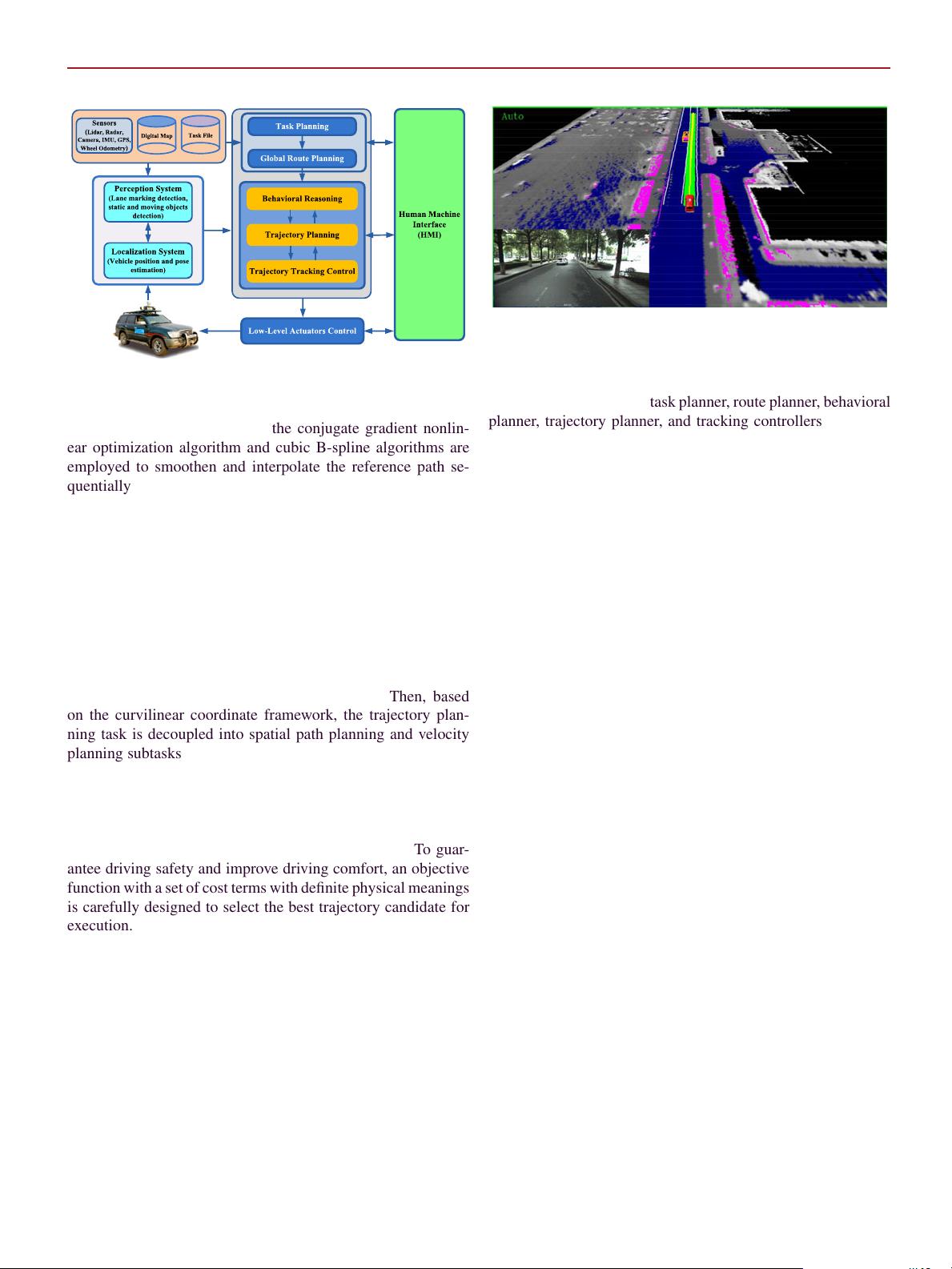
problem, we adopt a hierarchical motion planning frame-
work. First, a rough reference path is extracted from the
digital map using commands from the high-level behav-
ioral planner. The conjugate gradient nonlinear optimiza-
tion algorithm and the cubic B-spline curve are employed
to smoothen and interpolate the reference path sequentially.
To follow the refined reference path as well as handle both
static and moving objects, the trajectory planning task is
decoupled into lateral and longitudinal planning problems
within the curvilinear coordinate framework. A rich set of
kinematically feasible path candidates are generated to deal
with the dynamic traffic both deliberatively and reactively. In
the meanwhile, the velocity profile generation is performed
to improve driving safety and comfort. After that, the gen-
erated trajectories are carefully evaluated by an objective
function, which combines behavioral decisions by reason-
ing about the traffic situations. The optimal collision-free,
smooth, and dynamically feasible trajectory is selected and
transformed into commands executed by the low-level lat-
eral and longitudinal controllers. Field experiments have
been carried out with our test autonomous vehicle on the
realistic inner-city roads. The experimental results demon-
strated capabilities and effectiveness of the proposed tra-
jectory planning framework and algorithms to safely handle
a variety of typical driving scenarios, such as static and
moving objects avoidance, lane keeping, and vehicle fol-
lowing, while respecting the traffic rules.
Index Terms
—Autonomous urban driving, real-time
trajectory planning, static obstacles and moving objects
avoidance.
I. INTRODUCTION AND STAT E-OF-THE-ART
A
UTONOMOUS driving technologies have great potentials
to improve driving safety by reducing traffic accidents and
fatalities caused by human errors, enhance driving efficiency by
Manuscript received April 29, 2015; revised August 3, 2015; accepted
October 19, 2015. Date of publication October 26, 2015; date of cur-
rent version February 24, 2016. Recommended by Technical Editor C.
Manzie. This work was supported by the National Nature Science Foun-
dation of China under Grant 90820302.
X. Li, Z. Sun, Z. He, and Q. Zhu are with the College of Mechatronic
Engineering and Automation, National University of Defense Technol-
ogy, Changsha 410073, China (e-mail: xiaohui_lee1986@hotmail.com;
sunzhenping@outlook.com; hezhen.nudt@gmail.com; zhq_cs@126.
com).
D. Cao is with the Department of Automotive Engineering, Cranfield
University, Cranfield MK43 0AL, U.K. (e-mail: d.cao@cranfield.ac.uk).
Color versions of one or more of the figures in this paper are available
online at http://ieeexplore.ieee.org.
Digital Object Identifier 10.1109/TMECH.2015.2493980
reducing traffic congestion, as well as provide mobility for peo-
ple who are not able to drive [1]–[3]. Fully autonomous driving
is generally identified as the ultimate goal of driver assistance
systems in the future [4]. The past three decades have witnessed
the significant development of autonomous driving technolo-
gies, which have drawn unprecedentedly considerable attention
from both academia and industry. Tremendous research efforts
have been contributed toward the ambitious goal of realizing
fully autonomous driving on realistic roads [5]–[7].
Particularly in the last decade, with the advent of advances
in sensors, computer technologies, and artificial intelligence,
autonomous-driving-related research topics have become ex-
traordinarily active in both the robotics community and the au-
tomotive industry [8]–[12]. Among these well-known research
projects, the DARPA Urban Challenge in 2007 could be rec-
ognized as a turning point in demonstrating the potentials of
autonomous vehicles driving in urban environments. After that,
research groups in both universities and companies are continu-
ously studying autonomous driving technologies to investigate
necessary technologies for autonomous driving on public roads.
Very recently, there has existed a number of impressive research
projects on testing autonomous vehicles driving in urban and
highway environments [13]–[19].
When autonomous ground vehicles (AGVs) advance toward
the realistic urban road traffic, they are required to be capable
of handling various complex maneuvers, such as lane keep-
ing, vehicle following, lane changing, merging, avoiding both
static and dynamic objects, and interacting with other traffic par-
ticipants while complying with the traffic rules. Developing a
robotic vehicle to have these functionalities requires the system-
atic integration of state-of-the-art technologies in perception,
localization, decision making, motion planning, and control. As
one of these core technologies, motion planning plays a critical
role in guaranteeing driving safety and comfort. In general, the
challenges of developing a reliable and robust on-road motion
planner lie in the following factors: 1) generating dynamically
feasible trajectories in real time with limited onboard compu-
tational resources; 2) dealing with the unpredictably changing
surrounding environments with limited sensing range and vis-
ibility as well as the uncertainty and noise in the perception
and localization systems; 3) interacting with other traffic partic-
ipants, such as vehicles, cyclists, and pedestrians.
Based upon a large amount of previous research on this topic
in the literature, this paper focuses on solving the trajectory
planning problem in urban driving scenarios in a practical way
instead of a theoretical way.
1083-4435 © 2015 IEEE. Personal use is permitted, but republication/redistribution requires IEEE permission.
See http://www.ieee.org/publications
standards/publications/rights/index.html for more information.
LI
et al.
: REAL-TIME TRAJECTORY PLANNING FOR AUTONOMOUS URBAN DRIVING 741
A. Related Work
In recent years, a significant amount of work has been dedi-
cated to solving the motion planning problem for AGVs. These
approaches can be roughly categorized into two classes. One
focuses on computing collision-free paths using deterministic
graph search, such as Hybrid A* in [20] and [21], state-lattice
approaches in [22] and [23], or random sampling-based algo-
rithms, like rapidly exploring random tree (RRT) [24]. Most of
these graph-search approaches are capable of computing long-
term collision-free paths in cluttered environments and prevent-
ing the vehicle from getting stuck into local minima. These
powerful path-based motion planners are suitable for AGVs
navigating in complex unknown environments at low speeds.
However, most of these search-based algorithms assume that
environments are static in each plan cycle. In addition, the gen-
erated paths are often comprised of concatenated short-term
precomputed motion primitives without considering velocity
planning. As a result, they may easily result in stop-and-redirect
motions. In addition, they are usually too computationally de-
manding to run in real time or react to typical dynamic traffic
situations in urban environments. Therefore, these graph-search
algorithms are not suitable for vehicles driving in urban and
highway environments with moving objects. When vehicles
drive in structured environments, the feasible paths are often
strictly constrained by the geometry of roads, which signifi-
cantly reduces the solution space of drivable paths. However,
due to the presence of dynamic traffic participants, the motion
planner is required to explicitly take both lateral and longitudinal
movements into account.
There has been substantial research on real-time local
trajectory generation for AGVs driving in urban environments.
A well-known and efficient strategy follows a discrete opti-
mization scheme. To generate dynamically feasible trajectory
candidates, a model-predictive motion planner is proposed
in [11]. The control inputs are assumed to be curvature
polynomials, which significantly reduce the solution space
and guarantee the expressiveness of the generated trajec-
tories as well. Using the same idea, the approach in [25]
generates a finite set of nudges and swerves with different
lateral offsets shifting from a reference path. A similar approach
is adopted in [26] considering both lateral and longitudinal
movements within the street-relative coordinate. Considering
both vehicle motion model and the associated closed-loop
feedback control laws, a sampling-based motion planner is
proposed in [27], which ensures that the generated trajectories
could be accurately tracked. A similar strategy is also referred
in [24].
Based on the Boss work in DARPA Urban Challenge [11],
an extended trajectory planner is proposed for highway auto-
mated driving using spatiotemporal lattice conforming to the
road geometry [28]. Graphic processor units (GPUs) are uti-
lized to generate thousands of long-term trajectory candidates
in real time. The motion planner demonstrated its ability to han-
dle imminent situations in structured environments. However,
always simultaneously considering both spatial and temporal
dimensions with high resolution makes the search space pro-
hibitively large. Additionally, it is difficult to ensure the temporal
consistency between consecutive replans. Besides, the approach
assumes that the other traffic participants’ motions could be pre-
cisely predicted within a finite horizon. Based on his work, to
reduce the computation time while retaining the performance of
the spatiotemporal motion planner, a hierarchical motion plan-
ner is proposed to address the complex motion planning prob-
lems in both urban and highway driving within one framework
[29]–[32].
Instead of applying the discrete optimization scheme, very
recent work in [33] formulated the trajectory planning problem
as a nonlinear optimization problem with a number of inequal-
ity constraints. Extracting a reference corridor using the digital
map, vision-based localization information, and high-level de-
cision process, the trajectory planner explicitly considered hard
constraints imposed by both static obstacle and dynamic traf-
fic participants, as well as the physical constraints, like maxi-
mal steering curvature. The sequential quadratic programming
method is applied to solve the computationally demanding op-
timization problem in the continuous state space.
Most of the previous work does not take uncertainties of the
prediction and interactions with other traffic participants into
account. In [34] and [35], to assess the safety of the planned
paths, uncertainties originating from the measurements and pos-
sible behaviors of other traffic participants are considered in a
stochastic way. Besides, the interaction with other traffic par-
ticipants, as well as the limitation of driving maneuvers due
to the road geometry are also explicitly taken into account. In
[36], a compact representation for the on-road environment, the
dynamic probability drivability map, is presented for predic-
tive lane change and merge driver assistance during highway
and urban driving environments. The uncertainties of both ego-
vehicle and other participants are predicted based on Gaussian
propagation in [37].
B. Contributions and Novelties
Based upon the aforementioned previous work, the main con-
tribution of this paper is the introduction of a practical real-time
trajectory generation framework and algorithms for AGVs driv-
ing in realistic urban environments. To handle various dynamic
urban traffic situations both deliberatively and reactively, we
adopt a “divide-and-conquer” strategy. More precisely, a hi-
erarchical framework is employed. The high-level behavioral
planner is responsible for reasoning about complex dynamic
traffic situations and making deliberate discrete maneuver deci-
sions, such as lane following, lane changing, vehicle following,
overtaking a slow-moving vehicles, and so forth. Using the be-
havioral decision, the trajectory generation algorithm assumes
responsibility for generating dynamically feasible and collision-
free trajectories, which could be easily tracked by low-level
tracking controllers. This paper focuses on investigating the
real-time trajectory generation algorithm.
The rough reference path is extracted from the digital map
using the lane-level accurate localization information via the
LiDAR-based localization method, which is similar to the ap-
proaches proposed in [38] and [39]. To improve driving comfort
决策模块
742 IEEE/ASME TRANSACTIONS ON MECHATRONICS, VOL. 21, NO. 2, APRIL 2016
Fig. 1. Software system architecture for the AGV.
and reduce the control efforts, the conjugate gradient nonlin-
ear optimization algorithm and cubic B-spline algorithms are
employed to smoothen and interpolate the reference path se-
quentially. In realistic urban environments, AGVs are required
to always pay attention to the unpredictably changing traffic
situations, generating dynamically feasible trajectories while
avoiding both static and moving objects in real time. To achieve
this, the trajectory planner is performed to handle the dynamic
traffic situations in a reactive manner by explicitly considering
constraints imposed by the vehicle kinematics and dynamics,
as well as environments. Using the deliberative decisions gen-
erated by the behavioral planner, the trajectory planner is able
to focus on the solution space, where the optimal solution is
mostly like to exist. Besides, aggressive actions could also be
avoided in most nonimminent traffic situations. Then, based
on the curvilinear coordinate framework, the trajectory plan-
ning task is decoupled into spatial path planning and velocity
planning subtasks. Instead of using the optimization scheme to
produce a sole optimal trajectory in each replan cycle, the tra-
jectory planner is capable of generating a rich set of suboptimal
candidates, which could efficiently overcome the noise in the
perception and localization systems. Besides, it ensures that the
vehicle is able to safely stop in imminent situations. To guar-
antee driving safety and improve driving comfort, an objective
function with a set of cost terms with definite physical meanings
is carefully designed to select the best trajectory candidate for
execution.
The remainder of this paper is organized as follows. Section
II describes the system framework. The trajectory planning al-
gorithms is introduced in Section III. Section IV presents the
trajectory evaluation and optimization approach. The experi-
mental results in realistic urban scenarios are discussed in detail
in Section V. Section VI draws conclusions and suggests future
work.
II. S
YSTEM FRAMEWORK
An overview of the software system architecture for the AGV
is outlined in Fig. 1. The system is comprised of a variety of
modules, such as sensors, a digital map, task files, the perception
Fig. 2. Illustration of perception and localization systems.
and localization systems, task planner, route planner, behavioral
planner, trajectory planner, and tracking controllers, low-level
actuators control, and human machine interface (HMI). Each
module communicates with other modules via an specific pub-
lish/subscribe message passing protocol based on the Inter Pro-
cess Communication Toolkit.
Sensors, such as LiDARs, radars, and cameras, provide the
sensing information of surrounding environments in real time.
Additionally, other sensors, like the GPS combined with inertial
measurement unit (IMU) and the wheel encoders are used to
obtain the vehicle’s rough localization information. The sens-
ing information is mainly applied for two purposes: one is for
the perception system, such as detecting lane markings, traffic
lights, as well as static and dynamic objects (e.g., pedestrians,
cyclists, and the other vehicles); the other is to realize accu-
rate and robust localization. To achieve lane-level accurate and
reliable localization, many researchers take advantage of map-
ping and localization technologies using GPS, IMU, combined
with online 3-D points data from laser scanners [38], [40], [41]
or camera vision data [42]–[44].
In this paper, online sensing 3-D points data from the HDL-
64E Velodyne LiDAR combining with a high-resolution 3-D
map data recorded by manual driving have been applied to esti-
mate the vehicle’s position and pose in real time. Based on this
localization approach, the rich information of a prior digital map
could be exploited. In practice, we use a manually constructed
detailed digital map, which provides abundant traffic informa-
tion, such as lanes information (e.g., the position, the number,
and the topological relations) and traffic regulations (e.g., speed
limits). The details of the localization and map-constructed ap-
proach are not the main focus of this paper.
The results of perception and localization systems are illus-
trated in Fig. 2, the mother map is created offline using 3-D
points data of the LiDAR. The cells with magenta color are
online detected obstacles, including both dynamic and static
obstacles. The rectangular block represents the moving object
with arrows indicating its moving direction. The white lines in-
dicate the lanes based on the digital map. In practice, we find
that the localization method plays a critical role in guaranteeing
our autonomous vehicle safely driving in the dynamic urban
environments during the day and night, with sun or rain.
cost functions用来评估和挑选最优轨迹
剩余13页未读,继续阅读
资源评论
linxigjs
- 粉丝: 345
- 资源: 12
上传资源 快速赚钱
- 我的内容管理 展开
- 我的资源 快来上传第一个资源
- 我的收益 登录查看自己的收益
- 我的积分 登录查看自己的积分
- 我的C币 登录后查看C币余额
- 我的收藏
- 我的下载
- 下载帮助
安全验证
文档复制为VIP权益,开通VIP直接复制
信息提交成功