没有合适的资源?快使用搜索试试~ 我知道了~
5.Topological simultaneous localization and mapping (SLAM) towar...
需积分: 0 3 下载量 4 浏览量
2010-04-07
20:29:24
上传
评论
收藏 217KB PDF 举报
温馨提示
试读
13页
5.Topological simultaneous localization and mapping (SLAM) toward exact localization without explicit localization
资源详情
资源评论
资源推荐
IEEE TRANSACTIONS ON ROBOTICS AND AUTOMATION, VOL. 17, NO. 2, APRIL 2001 125
Topological Simultaneous Localization and Mapping
(SLAM): Toward Exact Localization Without
Explicit Localization
Howie Choset, Member, IEEE, and Keiji Nagatani, Member, IEEE
Abstract—One of the critical components of mapping an
unknown environment is the robot’s ability to locate itself on
a partially explored map. This becomes challenging when the
robot experiences positioning error, does not have an external
positioning device, nor the luxury of engineered landmarks
placed in its free space. This paper presents a new method for
simultaneous localization and mapping that exploits the topology
of the robot’s free space to localize the robot on a partially
constructed map. The topology of the environment is encoded in
a topological map; the particular topological map used in this
paper is the generalized Voronoi graph (GVG), which also encodes
some metric information about the robot’s environment, as well.
In this paper, we present the low-level control laws that generate
the GVG edges and nodes, thereby allowing for exploration of
an unknown space. With these prescribed control laws, the GVG
(or other topological map) can be viewed as an arbitrator for a
hybrid control system that determines when to invoke a particular
low-level controller from a set of controllers all working toward
the high-level capability of mobile robot exploration. The main
contribution, however, is using the graph structure of the GVG,
via a graph matching process, to localize the robot. Experimental
results verify the described work.
Index Terms—Exploration, localization, mapping, mobile
robots, motion planning, tologoical maps, Voronoi diagrams.
I. INTRODUCTION
S
ENSOR-BASED exploration enables a robot to explore an
unknownenvironment and build a map of that environment.
A critical component of this task is the robot’s ability to ascer-
tain its location in the partially explored map or to determine
that it has entered new territory. Naively, one can determine the
coordinates of the robot using dead-reckoning, a process
that determines the robot’s location by integrating data from
wheel encoders that count the number of wheel rotations (or
fractional rotations). Dead-reckoning fails to accurately posi-
tion the robot for many reasons, including wheel slippage. If
Manuscript received January 4, 2000; revised October 23, 2000. This paper
was recommended for publication by Associate Editor L. Kavraki and Editor
A. De Luca upon evaluation of the reviewers’ comments. This work was sup-
ported by T. McMullen at ONR under Grant 97PR06977 and H. Moraff, J. Xiao,
L. Reeker, and E. P. Glinert at NSF under Grant IRI-9702768. This paper was
presented in part at the International Conference on Robotics and Automation,
Leuven, Belgium, 1998.
H. Choset is with the Department of Mechanical Engineering and
Robotics, Carnegie Mellon University, Pittsburgh, PA 15213 USA (e-mail:
choset@cs.cmu.edu).
K. Nagatani was with the Department of Mechanical Engineering and
Robotics, Carnegie Mellon University, Pittsburgh, PA 15213 USA. He is
now with the Man–Machine System Laboratory, Department of System
Engineering, Okayama University, Okayama 700-8530, Japan.
Publisher Item Identifier S 1042-296X(01)05570-7.
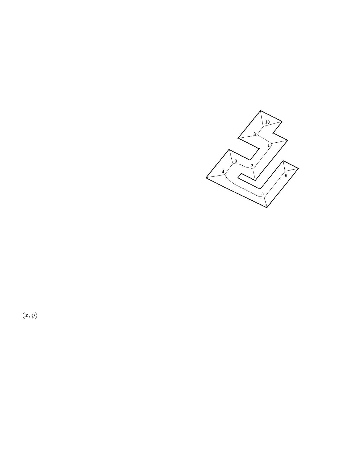
Fig. 1. The GVG where the symbols (nodes) are labeled 1–10.
the robot slips, the wheel rotation does not correspond to the
robot’s motion and thus encoder data, which reflect the state
of the wheel rotation, does not reflect the robot’s net motion,
thereby causing positioning error. A global positioning systems
(GPS) and inertial systems offer an alternative to dead-reck-
oning, but have their drawbacks as well. Finally, landmarks with
known locations can be deployed in the environment, but the
task described in this paper considers environments where their
geometry is completely unknown a priori. We do assume, how-
ever, that the unknown environment is static, planar, and that our
range sensors have sufficient range.
All robots that do not use preplaced landmarks or GPS must
employ a localization algorithm while mapping an unknown
space, hence the term simultaneous localization and mapping,
first coined by Leonard and Durrant-Whyte [16], [25]. This
paper takes a topological approach to SLAM. It is our belief
that the topological and geometric structure of free space induce
a natural hierarchy of symbols and connections among these
symbols that represent free space. At a high level, a topological
map [14] serves as an example of symbols and connections
between them. For Kuipers, the symbols are distinct places,
which are local maxima of the distance to nearby obstacles,
and the connections are the graph edges that link distinct
places. For an indoor office-like environments, junctions and
termination points of hallways represent symbols while the
hallways themselves are the connections. For the generalized
Voronoi graph (GVG) [21]; [7] (defined in Section II-A), the
Voronoi vertices (we call them meet points) are the symbols
while the edges form connections (Fig. 1).
1042–296X/01$10.00 © 2001 IEEE
126 IEEE TRANSACTIONS ON ROBOTICS AND AUTOMATION, VOL. 17, NO. 2, APRIL 2001
The connections of a high level representation can be dis-
cretized into a sequence of symbols with their corresponding
set of connections. Leonard and Durrant-Whyte’s approach to
SLAM is an excellent example [16], [25]. Their method uses
sensor information to define “features” and the relation among
them to direct a robot experiencing positioning error. Using a
Kalman filter approach to determine the “best” correlation of
features, the robot navigates similarly to a sailor using stars to
navigate a ship at night. Through the proper understanding of
the robot’s relationship to the features, the robot can maintain
an accurate estimate of its position while moving through the
environment using the features as low-level symbols that guide
the robot from one high-level symbol to the next.
At a low level, the robot’s environment can be modeled by
a local map such as a fine array of pixels [20]; [12]. Thrun
et al. [27] have been incredibly successful in demonstrating
their probabilistic approach in museum environments using
a grid-map representation. It is the belief of the authors that
Thrun’s main contribution is how to process a local map,
whether it be topological or a grid, not the local map itself.
Our contribution presented in this paper is to reduce the SLAM
problem to a graph matching problem at the topological scale,
not the graph matching itself.
Finally, defining the symbols and their connections is not
enough. Stable well-defined control laws must ensure that the
robot can identify (and converge onto if necessary) a symbol lo-
cation while at the same time move from symbol to symbol, i.e.,
traverse an edge. Although the philosophy of this work is gen-
eral to other topological maps, the map used in this paper is the
GVG, which is a map embedded in robot’s free space and cap-
tures the topologically salient features of the free space. With
the GVG the robot can plan a path between any two points in a
static environment by first planning a path onto the GVG, then
along the GVG, and finally from the GVG to the goal. Thus,
knowing the GVG is equivalent to knowing the free space and
constructing the GVG is akin to exploring the free space.
The GVG can be defined in an arbitrarily dimensioned Eu-
clidean space, but this paper stresses the planar version. We
present in this paper well-defined control laws that generate
GVGedges using line-of-sight range data. In deriving these con-
trol laws, we assume that the range and azimuth resolution of
the sensors are adequate to capture the structure of the robot’s
environment. Finally, we are assuming that the obstacles in our
environment are planar extrusions into three-dimensions, i.e.,
the obstacles are at the correct height for the sensors. With the
control laws, the GVG is not only a representation of free space
but it also forms a basis for exploring free space.
This paper presents some experimental results on how the
robot can incrementally construct the GVG in an unknown
space. Critical to this task is the robot’s ability to locate itself
on a partially constructed GVG. Although the robot locates
itself (topologically) on the GVG, it never needs to determine
its
coordinates (hence, the title of this paper). The robot
can propagate the coordinates of each point on the GVG from
the known location of one point, such as the start point, which
can be specified to be
.
In this paper, we first refer to prior work which has influenced
the authors’ thinking. Then, we define the GVG and prescribe
the control laws to construct it. Incrementally constructing the
GVG is not enough because of dead-reckoning error, as will be
shown by example. We then introduce a the following three-
tiered approach to localization: zero dimensional (using sensor
signatures of the nodes); one dimensional (intentionally fol-
lowing a sequence of edges to a desired node); and two di-
mensional (handling the situation where the robot accidentally
re-encounters an already-visited node). Finally, we discuss the
tradeoffs of this approach and future work.
II. R
ELATION TO PRIOR WORK
This work draws from two areas: sensor-based planning and
localization. Although both of these fields are vast, we only dis-
cuss papers that have influenced our thinking.
A. Sensor-Based Planning and Roadmaps
Much of the previous work in sensor-based planning is
heuristic and is limited to the plane. One class of heuristic
algorithms employs a behavior-based approach in which the
robot is armed with a simple set of behaviors (e.g., following
a wall) [4]. Another heuristic approach involves discretizing
a planar world into pixels of some resolution. Typically, this
approach handles errors in sonar sensing readings quite well
by assigning each pixel a value indicating the likelihood
that it overlaps an obstacle [20]; [2]. Many heuristics exist
for planning with the discretized map. Many behavior-based
heuristics are sometimes termed as reactive control in that low
level inputs directly affect the high level behavioral outcomes
for the robot. Strong experimental results indicate the utility
of these approaches, and thus these algorithms may provide a
future basis for complete sensor-based planners. Unfortunately,
these approaches currently neither afford proofs of correctness
that guarantee a path can be found, nor offer well-established
thresholds for when these heuristic algorithms fail. One of
the goals of the work presented here is to demonstrate how
low level inputs can direct a robot to construct a high-level
representation: a topological map.
We seek to adapt the structure of a provably correct classical
motion planning scheme to a sensor-based implementation.
For example, Lumelsky’s “bug” algorithm [19] proves that a
robot using on-line information can plan a path to the goal.
This method, however, does not yield a map of an unknown
space. Our approach is based on a roadmap [5], a one-dimen-
sional subset of a robot’s free space, which captures all of its
important topological properties. A roadmap has the following
properties: accessibility; connectivity; and departability. These
properties imply that the planner can construct a path between
any two points in a connected component of the robot’s free
space by first finding a path onto the roadmap (accessibility),
traversing the roadmap to the vicinity of the goal (connectivity),
and then constructing a path from the roadmap to the goal
(departability). If the robot can incrementally construct the
roadmap, then it has in essence explored its free space because
the robot can always use the roadmap to plan future excursions
into the free space.
Already, the motion planning field has produced many
roadmaps: silhouette methods [5], Voronoi diagrams [21],
CHOSET AND NAGATANI: TOPOLOGICAL SLAM: TOWARDS EXACT LOCALIZATION WITHOUT EXPLICIT LOCALIZATION 127
visibility graphs [15], etc. (see [15] for a survey of roadmaps).
The roadmap used in this work is the GVG [7], which is the
one-dimensional set of points equidistant to
obstacles in
dimensions. In the plane, the GVG is simply the generalized
Voronoi diagram, which is the set of points equidistant to two
obstacles [21]. In a three-dimensional Euclidean space
, the
GVG is the one-dimensional set of points equidistant to three
obstacles.
Rao [22] achieves exploration by incrementally constructing
the planar GVG in a two-dimensional static polygonal envi-
ronment. Choset and Burdick [6] also describe a method to
construct the GVG in a static
-dimensional environment, but
their approach does not require obstacles to be polygonal, poly-
hedral, nor convex, which are assumptions most motion plan-
ners require. Both methods assume that the robot only uses
line-of-sight information.
Both Rao’s and Choset and Burdick’s methods also assume
that the robot is equipped with a 360
field-of-view high az-
imuth infinite range sensor that detects nearby obstacles. They
do not consider how real range readings can be integrated into
a control law to direct a mobile robot. In this paper, we present
control laws that take low level sensor information and then di-
rects the robot to follow the GVG edges without knowing the
GVG ahead of time. This has the affect of incrementally con-
structing the GVG. Here, low level reactive-style control has a
direct affect on high level behavior of the robot which guaran-
tees that the robot explores an unknown space. This control law
works well in small environments with a mobile robot equipped
with a ring of sonar sensors [9]. Unfortunately the control laws,
by themselves, are not enough for deploying a robot in large
environments because of errors in encoder readings. The main
contribution of this paper is to use the topology encoded in the
GVG to overcome these errors and to localize the robot.
B. Localization
Localization is a major area of mobile robotics that has
received increased attention over the past decade. Again, the
literature in this field is vast, so only work which has influenced
this paper’s results are mentioned. See [3] for a complete
overview of current localization techniques. Lu et al. [17], [18],
[13] use gradient ascent to update various location estimates
forward and backward in time. As a result, this approach has
led to significantly larger maps that are more accurate than
previous approaches, but is still limited to situations with
bounded odometric error. Shatkay and Kaelbling [24] proposed
an approach that uses probabilistic representations, along
with the well-known Baum–Welch algorithm for efficient
estimation. Their approach is similar in nature to the one
described by Thrun [27], in that they both employ probabilistic
representations and both use the Baum–Welch algorithm.
However, the method in [24] does not consider orientation
dead-reckoning error.
Thrun has recently completed a localization approach that
has been successfully verified in very large environments on
a mobile robot where a map is known a priori or the robot
is driven (currently by an external agent) to acquire environ-
mental information [27]. This approach poses a maximum-like-
lihood estimation problem, where both the location of land-
marks and the robot’s position have to be estimated. Likelihood
is maximized under probabilistic constraints that arise from the
physics of robot motion and perception. Just like [27], they use
a Baum–Welch (or alpha–beta) algorithm. Unfortunately, this
approach requires a user to specify the landmarks, as opposed
to the robot self-selecting them. Also, their approach does not
include an exploration strategy. In other words, there is nothing
in their approach that directs the robot to explore new areas, or
that guides the robot to specific locations to reduce dead-reck-
oning error.
C. Localization with Topological Maps
The above localization techniques took the approach of con-
stantly trying to update the robot’s
coordinates relative
to a global frame. In this paper, we localize the robot on a topo-
logical map without ever having to do so explicitly. Others such
as Dudek [11] and Kuipers [14] have reported localization re-
sults with the same philosophy. In [11], an agent locates itself
on a graph by matching nodes and the adjacency relationships
between them. This approach assumes that the agent can label
each node by depositing a marker at the nodes. The approach in
this paper and in [14] has the robot automatically identify nodes
in the topological graph from geometric environmental infor-
mation.
The basic thrust of this paper’s work is quite similar to
Kuiper’s. In [14], the robot essentially traces points that are
equidistant from two portions of the environment until it
reaches a point that is three-way equidistant or until it reaches a
point where a distance threshold is met, at which point the robot
follows the obstacle boundaries. The nodes in this graph are
termed distinct places, which are local maxima of the distance
to nearby obstacles. The robot can easily self-determine distinct
places from sensor data. Distinct places are a subset of the
nodes of the GVG, which are the set of points equidistant
to three obstacles (in other words, there exist examples of
triple equidistance that are not local maxima). Localization is
achieved again by matching distinct places of the graph.
D. Simultaneous Localization and Mapping (SLAM)
Leonard and Durrant-Whyte coined the term SLAM, which
as its name suggests, enables a robot to construct a map of an
unknown environment while using the same map to bound or
nullify positioning errors [16]. With SLAM, the robot must au-
tomatically determine landmarks while constructing the map.
Smith and Leonard [25] developed a feature-based approach to
address SLAM by generating multiple hypothesis and selecting
among them while mapping an unknown region. The work pre-
sented here builds upon Leonard and Durrant-Whyte’s work by
determining a rigorously well-posed method for identifying fea-
tures and the topological relations among them.
Schultz et al. [23] present a more conventional approach to
SLAM that uses certainty grids. This approach is more of an
outgrowthof the algorithms presented in Section II-B. Although
this work does not directly impact the SLAM algorithm pre-
sented in this paper, Schultz and our approaches share some
common ideas and problems.
剩余12页未读,继续阅读
jpthank
- 粉丝: 1
- 资源: 12
上传资源 快速赚钱
- 我的内容管理 展开
- 我的资源 快来上传第一个资源
- 我的收益 登录查看自己的收益
- 我的积分 登录查看自己的积分
- 我的C币 登录后查看C币余额
- 我的收藏
- 我的下载
- 下载帮助
安全验证
文档复制为VIP权益,开通VIP直接复制
信息提交成功
评论0