ArcObject 10.3.1 For Java 对象模型(ODM)
需积分: 3 38 浏览量
2023-01-31
17:53:49
上传
评论
收藏 6.85MB PDF 举报

IMap
SceneExporter3D
ISceneExporter3d
1..*
CoClass
InterfaceD
InterfaceB
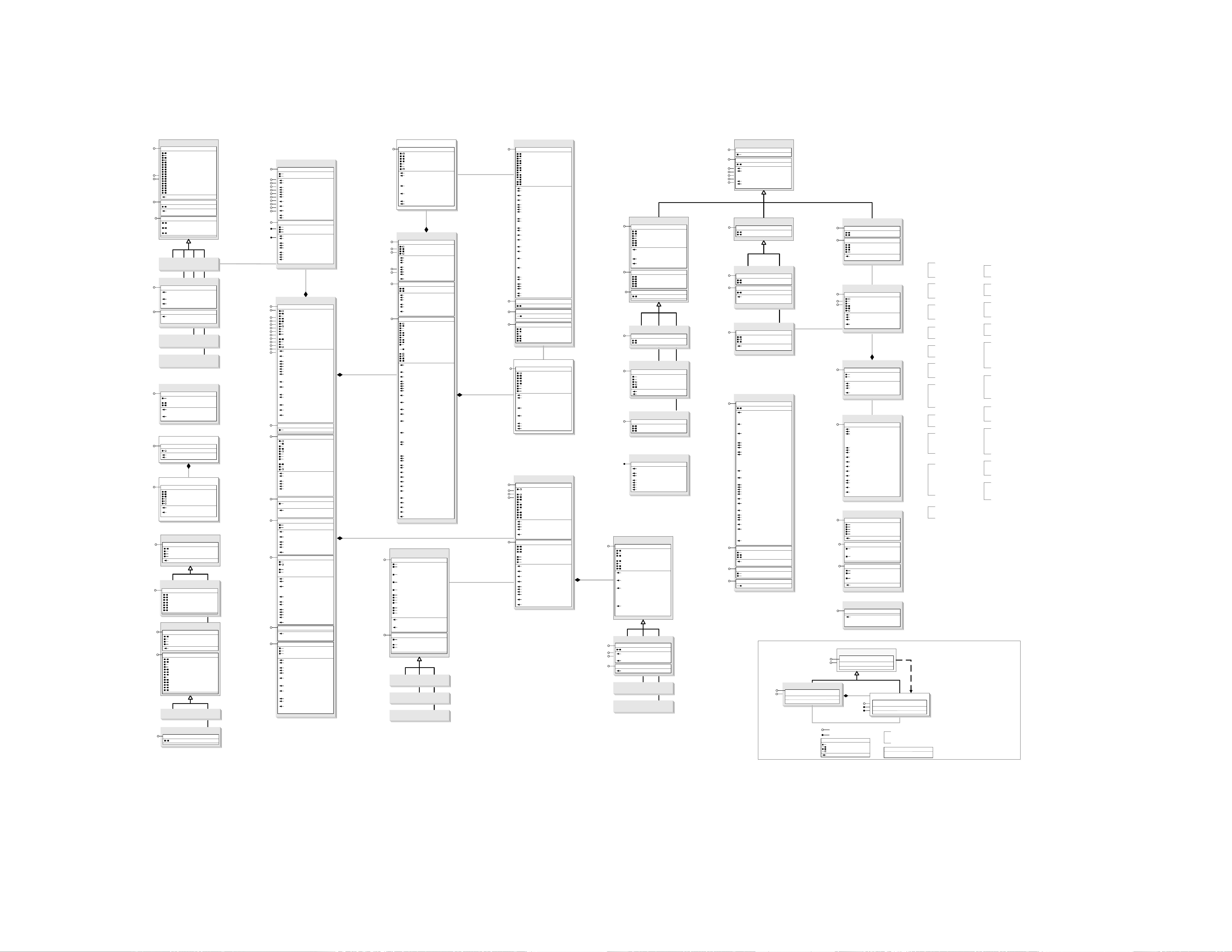
Types of Classes
An abstract class cannot be used to create new objects but is a specification
for instances of subclasses (through type inheritance.)
A CoClass can directly create objects by declaring a new object.
A Class cannot directly create objects, but objects of this class can be
created as a property of another class or instantiated by objects from
another class.
Types of Relationships
Associations represent relationships between classes. They have defined
multiplicities at both ends.
Type inheritance defines specialized classes of objects which share
properties and methods with the superclass and have additional properties
and methods. Note that interfaces in superclasses are not duplicated in
subclasses.
Instantiation specifies that one object from one class has a method with
which it creates an object from another class.
Composition is a relationship in which objects from the 'whole' class control
the lifetime of objects from the 'part' class.
An N-ary association specifies that more than two classes are associated. A
diamond is placed at the intersection of the association branches.
A Multiplicity is a constraint on the number of objects that can be associated
with another object. Association and composition relationships have
multiplicities on both sides. This is the notation for multiplicities:
1 - One and only one (if none shown, '1' is implied)
0..1 - Zero or one
M..N - From M to N (positive integers)
* or 0..* - From zero to any positive integer
1..* - From one to any positive integer
Class Diagram
Key
enumeration
firstValue - firstEnumeration
secondValue - secondEnumeration
AbstractClass
Type inheritance
Instantiation
Association
Composition
1..*
Multiplicity
Interface of interest
InterfaceA
(Optional)InterfaceB
Interface of interest
InterfaceG
InterfaceM
Outbound Interface
Inbound Interface
Special Interfaces
(Optional) represents interfaces that are
inherited by some subclasses but not all.
The subclasses list the optional
interfaces they implement.
(Instance) represents interfaces that are
only on specific instances of the class.
(<classname>) indicates the name of the
helper class required to support this
event interface in Visual Basic.
Interface key
Property Get
Property Put
Property Get/Put
Property Put by Reference
Method
(<classname>)InterfaceO
Structure key
<<Struct>>
firstMember: Type
secondMember: Type
Class
Interface of interest
Hit3DSet
IHit3DSet
IHit3DSet : IUnknown
Hits: IArray
OnePerLayer
Topmost (in factor: Double)
Hit3D
IHit3D
IHit3D : IUnknown
DistanceToObserver: Double
DistanceToRay: Double
ExactHit: Boolean
Object: IUnknown
Owner: IUnknown
Point: IPoint
GetDepthRange (out pDMin: Double, out
pDMax: Double)
SetDepthRange (in dMin: Double, in dMax:
Double)
0..*
SceneViewer Camera
ICamera
ICamera2
ICamera2 : ICamera
DisplayType: esriDisplayType
IStereoCamera
IStereoCamera : IUnknown
EyeSeparation: Double
EyeType: esriEyeType
IsStereoSupported: Boolean
LRviewFirst: esriEyeType
Parallax: Double
StereoViewType: esriStereoViewType
1..*
GraphicsLayer3D
IGraphicsContainer3D
IGraphicsContainer3D : IUnknown
Element (in index: Long): IElement
ElementCount: Long
AddElement (in Element: IElement)
AddElements (in elements:
IElementCollection)
BeginBatchUpdate
DeleteAllElements
DeleteElement (in Element: IElement)
EndBatchUpdate
LocateElements (in pPoint: IPoint, in
tolerance: Double): IEnumElement
LocateElementsByEnvelope (in pEnvelope:
IEnvelope): IEnumElement
MoveElementFromGroup (in pGroup:
IGroupElement, in pElement: IElement)
MoveElementToGroup (in pElement:
IElement, in pGroup: IGroupElement)
Next: IElement
Reset
IActiveViewEvents
IConnectionPointContainer
IGeoDataset
IGraphicsLayer
ILayer
ILayerEffects
ILayerEvents
ILayerExtensions
IPersist
IPersistStream
IPublishLayer
ISceneRendererEvents
IGraphicsSelection
IGraphicsSelection : IUnknown
SelectedElementCount: Long
SelectedElements: IEnumElement
SelectedElementsExtent: IEnvelope
DeleteAllSelectedElements
ElementSelected (in Element: IElement):
Boolean
SelectAllElements
SelectElement (in pElement: IElement)
SelectElements (in pElements:
IEnumElement)
SwitchSelection
UnselectAllElements
UnselectElement (in pElement: IElement)
UnselectElements (in pElements:
IEnumElement)
Feature3DProperties
IFeature3DProperties2
IFeature3DProperties2 : IFeature3DProperties
LocateSymbolized (in hint: Long, in
pQueryRay: IRay, in pLayer: IFeatureLayer,
out ppFeat: IFeature, out ppPoint: IPoint)
IFeature3DProperties
Basic3DProperties
Raster3DProperties
Tin3DProperties
3DProperties
I3DProperties
I3DProperties : IUnknown
BaseExpressionString: String
BaseName: IName
BaseOption: esriBaseOption
BaseSurface: IFunctionalSurface
DepthPriorityValue: Integer
ExtrusionExpressionString: String
ExtrusionType: esriExtrusionType
FaceCulling: esri3DFaceCulling
Illuminate: Boolean
MaxRasterColumns: Long
MaxRasterRows: Long
MaxTextureMemory: Long
OffsetExpressionString: String
RenderMode: esriRenderMode
RenderRefreshRate: Double
RenderVisibility: esriRenderVisibility
SmoothShading: Boolean
ZFactor: Double
Apply3DProperties (in Owner: IUnknown)
IPersist
IPersistStream
IDataLayerExtension
IDataLayerExtension : IUnknown
RelativeBase: String
Connect (in pOptRepairName: IName):
Boolean
Marker3DPlacement
IMarker3DPlacement
Enumerations
esri3DAxis
0 - esriXAxis
1 - esriYAxis
2 - esriZAxis
esri3DFaceCulling
0 - esriFaceCullingNone
1 - esriFaceCullingFront
2 - esriFaceCullingBack
esri3DMarkerType
0 - esri3DMTSimple
1 - esri3DMTGeometry
2 - esri3DMTGeomMaterial
esri3DOutputImageType
1 - BMP
2 - JPEG
esri3DProjectionType
1 - esriPerspectiveProjection
2 - esriOrthoProjection
esriBaseOption
0 - esriBaseExpression
1 - esriBaseSurface
2 - esriBaseShape
esriCameraMovementType
1 - esriCameraMoveAway
2 - esriCameraMoveToward
3 - esriCameraMoveLeft
4 - esriCameraMoveRight
5 - esriCameraMoveUp
6 - esriCameraMoveDown
esriDisplayType
1 - esriNonstereoDisplay
2 - esriStereoDisplay
esriExtrusionType
0 - esriExtrusionNone
1 - esriExtrusionMinZ
2 - esriExtrusionMaxZ
3 - esriExtrusionBase
4 - esriExtrusionAbsolute
esriEyeType
1 - esriLeftEye
2 - esriRightEye
esriRenderMode
0 - esriRenderCache
1 - esriRenderImmediate
esriRenderVisibility
0 - esriRenderAlways
1 - esriRenderWhenStopped
2 - esriRenderWhenNavigating
esriSceneGeomNodeType
0 - esriSceneGeomGeographyNode
1 - esriSceneGeomGraphicsNode
esriSceneNodeType
0 - esriSceneAnyNode
1 - esriSceneGroupNode
2 - esriSceneGeometryNode
3 - esriSceneChoiceNode
4 - esriSceneTransformNode
5 - esriSceneLayerNode
6 - esriSceneTileNode
esriScenePickMode
1 - esriScenePickGeography
2 - esriScenePickGraphics
3 - esriScenePickAll
4 - esriScenePickAllPlus
5 - esriScenePickPlane
6 - esriScenePickSphere
esriSceneTraversalFlag
1 - esriSceneDrawTraversal
2 - esriScenePickTraversal
4 - esriSceneImmediateDrawTraversal
8 - esriSceneTransparencyTraversal
16 - esriSceneDrawWhileNavigateTraversal
32 - esriSceneDrawWhileStillTraversal
64 - esriSceneLightingTraversal
128 - esriSceneSmoothShadingTraversal
256 - esriSceneNeedMBBUpdateTraversal
esriSimple3DLineStyle
0 - esriS3DLSTube
1 - esriS3DLSStrip
2 - esriS3DLSWall
esriSimple3DMarkerStyle
0 - esriS3DMSTetra
1 - esriS3DMSCube
2 - esriS3DMSCone
3 - esriS3DMSCylinder
4 - esriS3DMSDiamond
5 - esriS3DMSSphere
6 - esriS3DMSSphereFrame
esriStereoViewType
1 - esriRedBlueStereoView
2 - esriQuadBufferedStereoView
3 - esriFreeStereoView
0..*
0..*
IMarker3DPlacement : IMarkerSymbol
Depth: Double
MaintainAspectRatio: Boolean
NormalizedOriginOffset: IVector3D
Shape: IGeometry
Units: esriUnits
Width: Double
ZOffset: Double
ApplyToPoint (in inShape: IPoint, out
outShape: IGeometry, in enforcedZ:
Double, in unitFactor: Double, in zScale:
Double)
QueryRotationAngles (out xAngle: Double, out
yAngle: Double, out zAngle: Double)
SetRotationAngles (in xAngle: Double, in
yAngle: Double, in zAngle: Double)
IFeature3DProperties : IUnknown
ApplyFeatureProperties (in feature: IFeature,
out newGeometry: IGeometry, in
ignoreOffsetAndScale: Boolean)
Locate (in hint: Long, in pQueryRay: IRay, out
ppFeat: IFeature, out ppPoint: IPoint)
PrepareQueryFilter (in pFc: IFeatureClass, in
pQueryFilter: IQueryFilter)
ICamera : IUnknown
Azimuth: Double
Inclination: Double
IsUsable: Boolean
MultiPhaseRendering: Boolean
Observer: IPoint
OrthoViewingExtent: IEnvelope
ProjectionType: esri3DProjectionType
RollAngle: Double
Scale: Double
Target: IPoint
UpDirection: IVector3D
VerticalExaggeration: Double
ViewFieldAngle: Double
ViewingDistance: Double
CanSeeMBB (in pExtent: IEnvelope): Boolean
CanSeeSphere (in pCenter: IPoint, in radius:
Double): Boolean
GetIdentifyRay (in dx: Long, in dy: Long): IRay
GetIdentifyVector (in pCursor: IPoint):
IVector3D
HTurnAround (in dAzimuth: Double)
LevelObsToTarget
LevelTargetToObs
Move (in direction:
esriCameraMovementType, in factor:
Double)
Pan (in startPoint: IPoint, in endPoint: IPoint)
PolarUpdate (in distanceFactor: Double, in
dAzimuth: Double, in dInclination: Double,
in bLimitInclination: Boolean)
PropertiesChanged
QueryDistanceToMBB (in pExtent: IEnvelope,
out distance: Double)
QueryDistanceToSphere (in pCenter: IPoint,
in radius: Double, out distance: Double)
QueryDistanceToSphereCenter (in pCenter:
IPoint, in radius: Double, out distance:
Double)
QueryIdentifyVector (in dx: Long, in dy: Long,
in pIdentifyVect: IVector3D)
QueryOrthoViewingPlatform (in pInExtent:
IEnvelope, in pOutExtent: IEnvelope, out
pScale: Double)
QueryViewingPlatformMBB (in pExtent:
IEnvelope, out pNearPlane: Double, out
pFarPlane: Double, out pAngle: Double, out
pAspect: Double)
QueryViewingPlatformSphere (in pCenter:
IPoint, in radius: Double, out pNearPlane:
Double, out pFarPlane: Double, out pAngle:
Double, out pAspect: Double)
RecalcUp
ReplayFrame (in pSceneGraph: ISceneGraph)
Rotate (in Angle: Double)
SetDefaultsMBB (in pExtent: IEnvelope)
SetDefaultsSphere (in pCenter: IPoint, in
radius: Double)
Zoom (in ratio: Double)
ZoomToRect (in pExtent: IEnvelope)
SceneGraph
IViewers3D
IViewers3D : IUnknown
ActiveViewer: ISceneViewer
GestureEnabled: Boolean
IsNavigating: Boolean
Scene: IScene
FindViewer (in Caption: String): ISceneViewer
GetAllViewers: IArray
GetBackgroundColor (out pRed: Single, out
pGreen: Single, out pBlue: Single)
RefreshViewers
RegisterViewer (in pViewer: ISceneViewer)
ReplayFrame (in Camera: ICamera)
SetBackgroundColor (in red: Single, in green:
Single, in blue: Single)
UnregisterViewer (in pViewer: ISceneViewer)
IActiveViewEvents
IConnectionPointContainer
ISceneRendererEvents
ISupportErrorInfo
IDisplay3D : IUnknown
ScreenPickTolerance: Long
SymbolScale: Single
AddFlashFeature (in pGeometry: IGeometry)
FlashFeatures
FlashGeometry (in pOwner: IUnknown, in
feature: IUnknown)
FlashLocation (in pGeometry: IPoint)
GetMaxTextureSize (out pMaxTextureWidth:
Long, out pMaxTextureHeight: Long)
PutMaxTextureSize (in maxTextureWidth:
Long, in maxTextureHeight: Long)
ISceneGraph
ISceneGraph : IUnknown
ActiveViewer: ISceneViewer
Contrast: Long
Extent: IEnvelope
GeographySelectionExtent: IEnvelope
GestureEnabled: Boolean
ImmediateMode: Boolean
IsEmpty: Boolean
IsNavigating: Boolean
IsRecordingMessageEnabled: Boolean
OwnerExtent (in pOwner: IUnknown, in
bSelectionOnly: Boolean): IEnvelope
OwnerExtrusion (in pObject: IUnknown):
Boolean
Scene: IScene
SelectionColor: IColor
SunVector: IVector3D
VerticalExaggeration: Double
AddSimpleActor (in pRecorder:
ISceneRenderer, in pGeoDataset:
IGeoDataset)
AddSimpleGraphics (in pRecorder:
ISceneRenderer)
BeginCompositeActor (in pGroupLayer:
ICompositeLayer)
Clear (in bKeepBasicGraph: Boolean)
EndCompositeActor
FindViewer (in Caption: String): ISceneViewer
GetAllViewers: IArray
GetBackgroundColor (out pRed: Single, out
pGreen: Single, out pBlue: Single)
GetDrawingTimeInfo (out
pLastFrameDuration: Double, out
pMeanFrameRate: Double)
GetOwnerSymbols (in pOwner: IUnknown, out
ppSymbols: IArray, out ppDisplayListIDs:
ILongArray)
GetOwnerTransparency (in pObject:
IUnknown, out pTranspPercent: Long)
Invalidate (in pObject: IUnknown, in
bInvalidateGeography: Boolean, in
bInvalidateSelection: Boolean)
Locate (in pViewer: ISceneViewer, in x: Long,
in y: Long, in mode: esriScenePickMode, in
bGetTransformed: Boolean, out ppPt:
IPoint, out ppOwner: IUnknown, out
ppObject: IUnknown)
LocateMultiple (in pViewer: ISceneViewer, in
x: Long, in y: Long, in mode:
esriScenePickMode, in bGetTransformed:
Boolean, out ppHits: IHit3DSet)
LockViewers (in lock: Boolean)
RecordSymbol (in pSymbol: ISymbol, in glList:
Long, in bIsExtruded: Boolean, in bLighting:
Boolean, in layerTransparencyPercent:
Long, in bOptimizeState: Boolean)
RefreshViewers
RegisterViewer (in pViewer: ISceneViewer)
Remove (in pObject: IUnknown, in
bUpdateExtent: Boolean)
ReplayFrame (in Camera: ICamera)
SetBackgroundColor (in red: Single, in green:
Single, in blue: Single)
SetOwnerDepthPriority (in pObject: IUnknown,
in depthPriority: Integer)
SetOwnerFaceCulling (in pObject: IUnknown,
in cullingMode: esri3DFaceCulling)
SetOwnerImmediateMode (in pObject:
IUnknown, in bIsLayerImmediate: Boolean)
SetOwnerLightingOption (in pObject:
IUnknown, in lighting: Boolean)
SetOwnerNavigationVisibility (in pObject:
IUnknown, in visibleWhenNavigating:
Boolean, in visibleWhenStill: Boolean)
SetOwnerShadingMode (in pObject:
IUnknown, in bIsSmooth: Boolean)
SetOwnerTimeThreshold (in pObject:
IUnknown, in timeThreshold: Double)
SetOwnerTransparencyState (in pObject:
IUnknown, in bIsTransparent: Boolean)
SetOwnerVisibility (in pObject: IUnknown, in
visible: Boolean)
UnregisterViewer (in pViewer: ISceneViewer)
SceneGraphEvents
ISceneGraphEvents
ISceneGraphEvents : IUnknown
ActiveViewerChanged (in pViewer:
ISceneViewer)
AfterDraw (in pViewer: ISceneViewer)
BeforeDraw (in pViewer: ISceneViewer):
Boolean
InteractionStopped
RecordingStarted (in Name: String)
RecordingStopped
ViewerAdded (in pViewer: ISceneViewer)
ViewerRemoved (in pViewer: ISceneViewer)
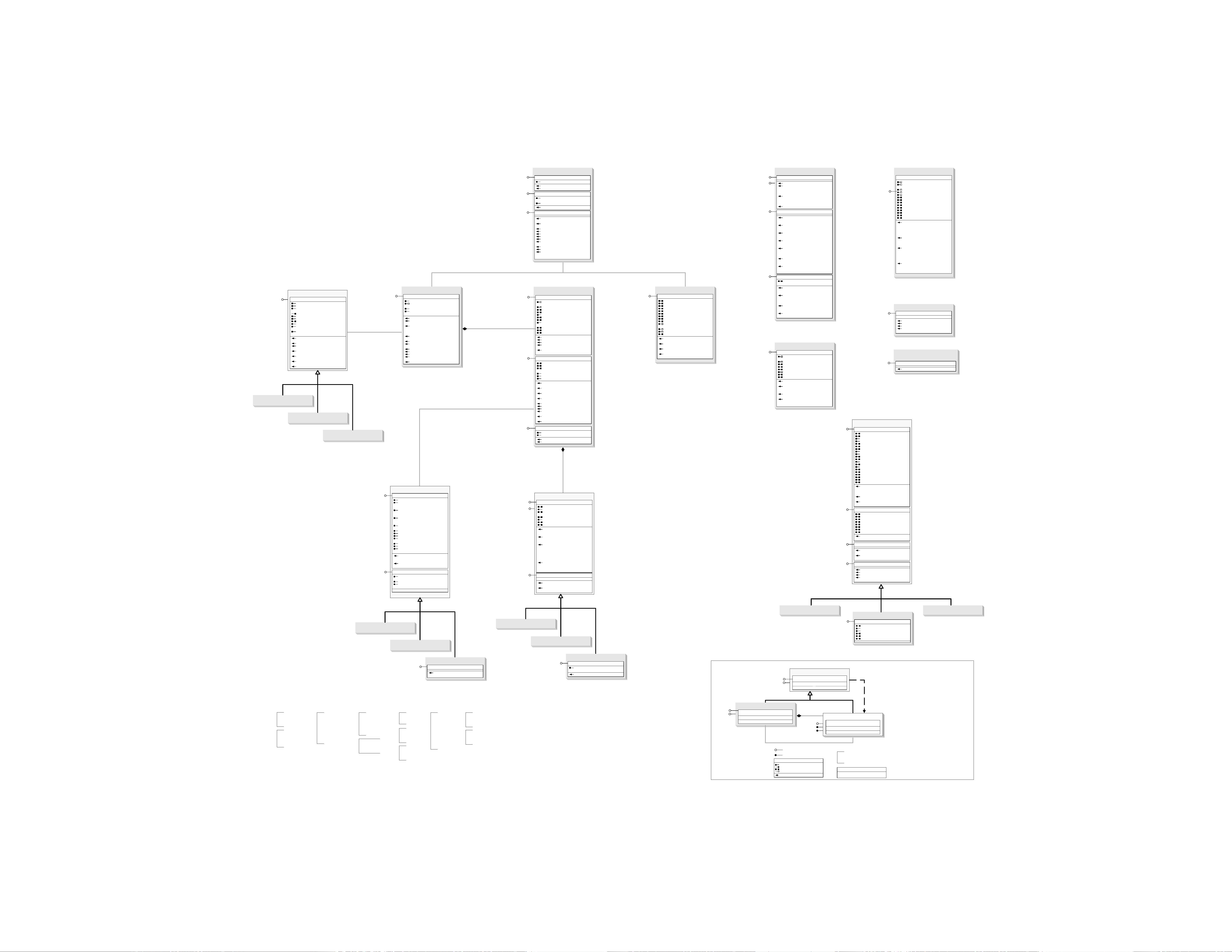
ArcGIS 3DAnalyst Object Model
Esri
®
ArcGIS
®
10.3.1
Copyright © 1999-2015 Esri. All rights reserved. Esri, ArcGIS, ArcObjects, and ArcMap are trademarks, registered trademarks, or service marks of Esri in the United
States, the European Community, or certain other jurisdictions.
(esriCarto)
esriDisplay.IDisplay3D
3DViewer
1..*
ICamera3 : ICamera2
OrthoViewingExtent: IEnvelope
ICamera3
3DSymbol
IClone
IPersist
IPersistStream
IPropertySupport
IDisplayName : IUnknown
NameString: String
esriDisplay.IDisplayName
esriDisplay.ISymbol
esriDisplay.IMapLevel
MessageDispatcher
IMessageDispatcher
IMessageDispatcher : IUnknown
Cancelled (in hWnd: OLE_HANDLE): Boolean
CancelOnClick: Boolean
CancelOnEscPress: Boolean
Dispatch (in hWnd: OLE_HANDLE, in bSingle:
Boolean, out pbCancelled: Variant)
Remove (in hWnd: OLE_HANDLE, in bSingle:
Boolean, out pbCancelled: Variant)
IMarkerSymbol : IUnknown
Angle: Double
Color: IColor
Size: Double
XOffset: Double
YOffset: Double
esriDisplay.IMarkerSymbol
SimpleLine3DSymbol
ISimpleLine3DSymbol
ISimpleLine3DSymbol : IUnknown
ResolutionQuality: Double
Style: esriSimple3DLineStyle
ILine3DPlacement
ILine3DPlacement : ILineSymbol
Units: esriUnits
ApplyToLine (in inShape: IGeometry, out
outShape: IGeometry, in enforcedZ:
Double, in zScale: Double)
TextureLineSymbol
ITextureLineSymbol
ITextureLineSymbol : ILineSymbol
BitmapTransparencyColor: IColor
Texture: IGeometryMaterial
VerticalOrientation: Boolean
CreateLineSymbolFromFile (in FileName:
String)
Line3DSymbol
ILineSymbol
ILineSymbol : IUnknown
Color: IColor
Width: Double
(esriDisplay)
(esriDisplay)
0..*
TextureFillSymbol
IFillSymbol
IFillSymbol : IUnknown
Color: IColor
Outline: ILineSymbol
ITextureFillSymbol
ITextureFillSymbol : IFillSymbol
Angle: Double
BitmapTransparencyColor: IColor
Size: Double
Texture: IGeometryMaterial
CreateFillSymbolFromFile (in FileName:
String)
GeometryMaterialList
IGeometryMaterialList
IGeometryMaterialList : IUnknown
Count: Long
GeometryMaterial (in index: Long):
IGeometryMaterial
AddMaterial (in pMaterial: IGeometryMaterial)
EmptyList
InsertMaterial (in index: Long, in pMaterial:
IGeometryMaterial)
RemoveMaterial (in index: Long)
GeneralMultiPatchCreator
IGeneralMultiPatchCreator
IGeneralMultiPatchCreator : IUnknown
ClearResources
CreateMultiPatch: IGeometry
Init (in PointCount: Long, in partCount: Long,
in hasMs: Boolean, in hasIDs: Boolean, in
hasNormals: Boolean, in
TexturePointCount: Long, in
pGeometryMaterialList:
IGeometryMaterialList)
SetID (in index: Long, in ID: Long)
SetM (in index: Long, in mValue: Double)
SetMaterialIndex (in patch: Long, in index:
Long)
SetNormal (in index: Long, in pVector:
IVector3D)
SetPatchPointIndex (in patch: Long, in index:
Long)
SetPatchPriority (in patch: Long, in priority:
Long)
SetPatchTexturePointIndex (in part: Long, in
index: Long)
SetPatchType (in patch: Long, in Type:
esriPatchType)
SetPoint (in index: Long, in pPoint: IPoint)
SetTexturePoint (in index: Long, in pPoint:
IPoint)
SetTextureWKSPoint (in index: Long, in
pPoint: WKSPoint)
SetWKSPointZ (in index: Long, in pPoint:
WKSPointZ)
GeometryMaterial
IGeometryMaterial
IGeometryMaterial : IUnknown
Color: IRgbColor
HasTransparentTextureColor: Boolean
TextureColorPalette: IArray
TextureImage: String
Transparency: Double
TransparentTextureColor: IRgbColor
ClearTextureImage
ClearTransparentTextureColor
GetColor (out pRed: Double, out pGreen:
Double, out pBlue: Double)
SetColor (in red: Double, in green: Double, in
blue: Double)
IPersist
IPersistStream
esriGeoDatabase.ISurface
RasterSurface
IRasterSurface
IRasterSurface : IUnknown
Raster: IRaster
RasterBand: IRasterBand
SampleDistance: Double
PutRaster (in Raster: IRaster, in bandIndex:
Long)
IFunctionalSurface : IUnknown
Domain: IPolygon
Z (X: Double, Y: Double): Double
IFunctionalSurface2 : IFunctionalSurface
Domain: IPolygon
ISurface : IFunctionalSurface
ZFactor: Double
AsPolygons (pFeatureClass: IFeatureClass, in
Type: esriSurfaceConversionType, in
pClassBreaks: IDoubleArray, in
pClassCodes: ILongArray, in FieldName:
Variant)
Contour (in rootHeight: Double, in interval:
Double, pFeatureClass: IFeatureClass, in
FieldName: String, in
digitsAfterDecimalPoint: Long)
ContourList (in pBreaks: IDoubleArray,
pFeatureClass: IFeatureClass, in
FieldName: String, in
digitsAfterDecimalPoint: Long)
GetAspectDegrees (in pPoint: IPoint): Double
GetAspectRadians (in pPoint: IPoint): Double
GetContour (in pPoint: IPoint, out ppContour:
IPolyline, out pElevation: Double)
GetElevation (in pPoint: IPoint): Double
GetLineOfSight (in pObserver: IPoint, in
pTarget: IPoint, out ppObstruction: IPoint,
out ppVisibleLines: IPolyline, out
ppInvisibleLines: IPolyline, out pbIsVisible:
Boolean, in bApplyCurvature: Boolean, in
bApplyRefraction: Boolean, in
pRefractionFactor: Variant)
GetProfile (in pShape: IGeometry, out
ppProfile: IGeometry, in pStepSize: Variant)
GetProjectedArea (in referenceHeight:
Double, in Type: esriPlaneReferenceType):
Double
GetSlopeDegrees (in pPoint: IPoint): Double
GetSlopePercent (in pPoint: IPoint): Double
GetSlopeRadians (in pPoint: IPoint): Double
GetSteepestPath (in pPoint: IPoint): IPolyline
GetSurfaceArea (in referenceHeight: Double,
in Type: esriPlaneReferenceType): Double
GetVolume (in reference: Double, in Type:
esriPlaneReferenceType): Double
InterpolateShape (in pShape: IGeometry, out
ppOutShape: IGeometry, in pStepSize:
Variant)
InterpolateShapeVertices (in pShape:
IGeometry, out ppOutShape: IGeometry)
IsVoidZ (in Value: Double): Boolean
Locate (in pRay: IRay, in hint: Long): IPoint
LocateAll (in pRay: IRay, in hint: Long):
IDoubleArray
QueryNormal (in pLocation: IPoint, pNormal:
IVector3D)
QueryPixelBlock (in xOrigin: Double, in
yOrigin: Double, in xPixelSize: Double, in
yPixelSize: Double, in Type:
esriRasterizationType, in valueForNoData:
Variant, in block: Variant)
QuerySurfaceLength (in pShape: IGeometry,
out pLength: Double, in pStepSize: Variant)
esriGeometry.IFunctionalSurface
esriGeometry.IFunctionalSurface2
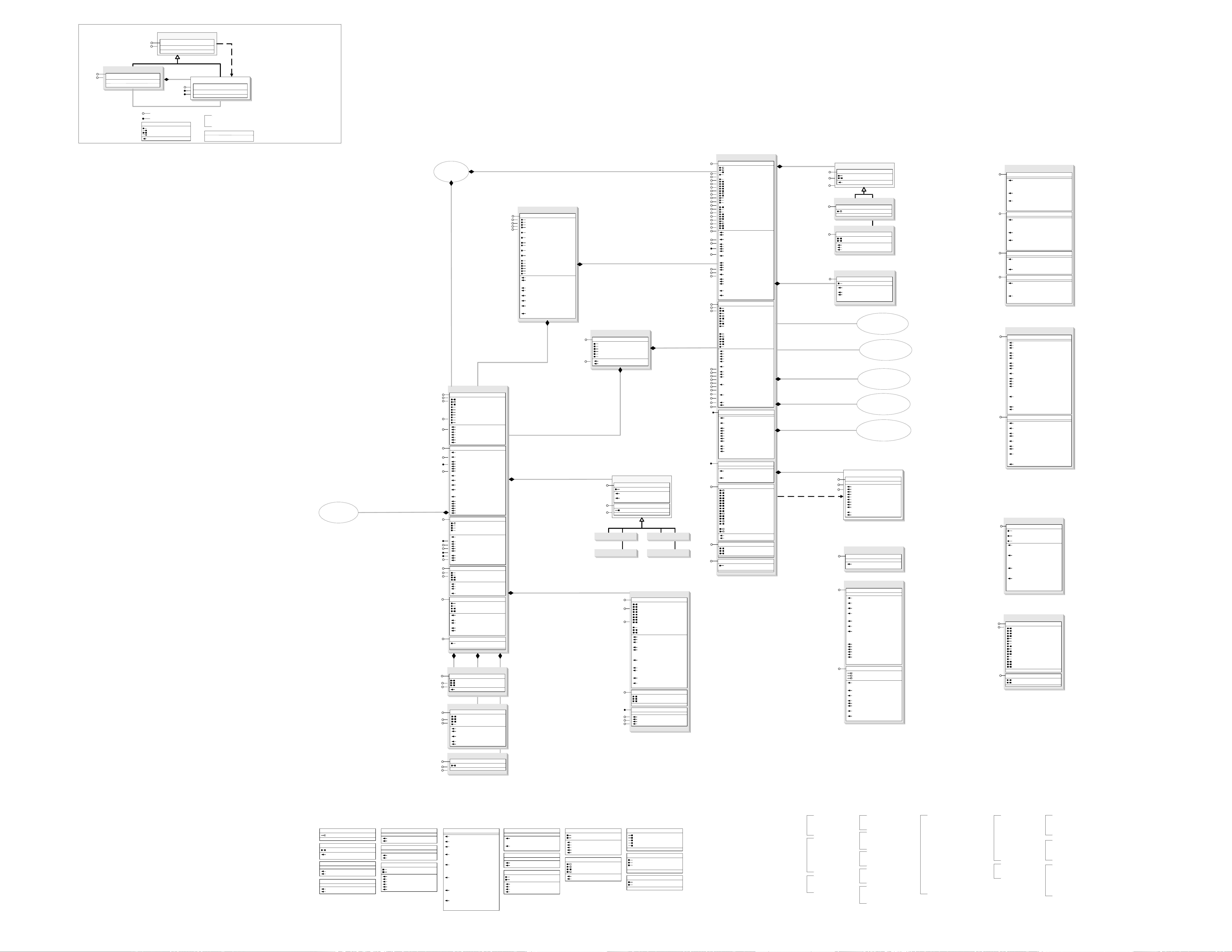
AnimationTypeLayer
AnimationTypeScene
AGAnimationType
AnimationTypeCamera
AGAnimationKeyframe
I3DProperties2 : I3DProperties
TextureCompressionType:
esriTextureFormatType
TextureDisplayType:
esriTextureFormatType
TextureDownsamplingFactor: Double
I3DProperties2
Scene
IScene : IUnknown
ActiveGraphicsLayer: ILayer
AreaOfInterest: IEnvelope
BasicGraphicsLayer: IGraphicsLayer
Description: String
ExaggerationFactor: Double
Extent: IEnvelope
FeatureSelection: ISelection
Layer (in index: Long): ILayer
LayerCount: Long
Layers (in uid: IUID, in recursive: Boolean):
IEnumLayer
Name: String
SceneGraph: ISceneGraph
SelectionCount: Long
SpatialReference: ISpatialReference
AddLayer (in pLayer: ILayer, in
autoArrange: Boolean)
AddLayers (in Layers: IEnumLayer, in
autoArrange: Boolean)
Applies (in Object: IUnknown): Boolean
ClearLayers
ClearSelection
DelayEvents (in delay: Boolean)
DeleteLayer (in Layer: ILayer)
GetDefaultBackgroundColor (out red:
Single, out green: Single, out blue:
Single)
MoveLayer (in Layer: ILayer, in toIndex:
Long)
ProposeSpatialReference (in
pProposedSR: ISpatialReference, out
pbChanged: Boolean)
RecalculateExtent
SelectByShape (in Shape: IGeometry, in
env: ISelectionEnvironment, in justOne:
Boolean)
SelectFeature (in Layer: ILayer, in
pFeature: IFeature)
SetDefaultBackgroundColor (in red: Single,
in green: Single, in blue: Single)
SuggestExaggerationFactor (in
aspectRatio: Double, out
ExaggerationFactor: Double)
IScene
IBasicScene
IMapLayers
ISelectionEvents
ITableCollection
IStandaloneTableCollection
IAnimationTracks
ISupportErrorInfo
IConnectionPointContainer
IPersistStream
IPersist
IActiveViewEvents
IBasicScene2 : IBasicScene
AnimationExtension: IAnimationExtension
IBasicScene2
IBasicMap : IUnknown
ActiveGraphicsLayer: ILayer
AreaOfInterest: IEnvelope
BasicGraphicsLayer: IGraphicsLayer
Description: String
FeatureSelection: ISelection
Layer (in Index: Long): ILayer
LayerCount: Long
Layers (in uid: IUID, in recursive: Boolean):
IEnumLayer
Name: String
SelectionCount: Long
SpatialReference: ISpatialReference
AddLayer (in pLayer: ILayer)
AddLayers (in pLayers: IEnumLayer, in
autoArrange: Boolean)
ClearLayers
ClearSelection
DeleteLayer (in pLayer: ILayer)
SelectByShape (in Shape: IGeometry, in
env: ISelectionEnvironment, in justOne:
Boolean)
IBasicMap
IRelationshipClassCollection : IUnknown
RelationshipClasses:
IEnumRelationshipClass
FindRelationshipClasses (in objectClass:
IObjectClass, in role: esriRelRole):
IEnumRelationshipClass
IRelationshipClassCollection
ISceneBookmarks : IUnknown
BookmarkCount: Long
Bookmarks: IArray
AddBookmark (in pBookmark:
IBookmark3D)
FindBookmark (in Name: String, out
ppBookmark: IBookmark3D)
LoadBookmarks (in pStm: IStream)
RemoveAllBookmarks
RemoveBookmark (in bookmark:
IBookmark3D)
SaveBookmarks (in pStm: IStream)
ISceneBookmarks
IAGAnimationTracks : IUnknown
AGTracks: IArray
AnimationObjectContainer:
IAGAnimationContainer
TrackCount: Long
TracksOfType (in pType:
IAGAnimationType): IArray
AddTrack (in pTrack: IAGAnimationTrack)
ApplyTracks (in bApplyToAllViewers:
Boolean, in time: Double)
ChangePriority (in pTrack:
IAGAnimationTrack, in bAbsolute:
Boolean, in bInSameType: Boolean, in
changeInIndex: Long)
CreateTrack (in pType:
IAGAnimationType): IAGAnimationTrack
DetachObject (in pObject: IUnknown)
FindTrack (in Name: String, out ppTrack:
IAGAnimationTrack)
LoadTracks (in pStm: IStream)
RefreshAttachedObjects
RemoveAllTracks
RemoveTrack (in pTrack:
IAGAnimationTrack)
SaveTracks (in pStm: IStream)
IAGAnimationTracks
ISceneViewer : IUnknown
Camera: ICamera
Caption: String
GestureEnabled: Boolean
GestureSensitivity: Long
hDC: OLE_HANDLE
hWnd: OLE_HANDLE
SceneGraph: ISceneGraph
ClearGesture
DrawToMetafile (in hDC: OLE_HANDLE, in
resolutionFactor: Single, in left: Long, in
top: Long, in right: Long, in bottom: Long,
in bOffScreen: Boolean)
GetScreenShot (in Type:
esri3DOutputImageType, in FileName:
String)
GetSnapshot (in Width: Long, in height:
Long, in Type: esri3DOutputImageType,
in FileName: String)
OverrideDefaultHandler
Redraw (in cameraMoved: Boolean)
ISceneViewer
ISymbol : IUnknown
ROP2: esriRasterOpCode
Draw (in Geometry: IGeometry)
QueryBoundary (in hDC: OLE_HANDLE, in
displayTransform: ITransformation, in
Geometry: IGeometry, in boundary:
IPolygon)
ResetDC
SetupDC (in hDC: OLE_HANDLE, in
Transformation: ITransformation)
I3DViewer : IUnknown
Camera: ICamera
Caption: String
FullScreenEnabled: Boolean
GestureEnabled: Boolean
GestureSensitivity: Long
hDC: OLE_HANDLE
hWnd: OLE_HANDLE
IsFullScreen: Boolean
ClearGesture
DrawToMetafile (in hDC: OLE_HANDLE, in
resolutionFactor: Single, in left: Long, in
top: Long, in right: Long, in bottom: Long,
in bOffScreen: Boolean)
GetScreenShot (in Type:
esri3DOutputImageType, in FileName:
String)
GetSnapshot (in Width: Long, in height:
Long, in Type: esri3DOutputImageType,
in FileName: String)
OverrideDefaultHandler
Redraw (in bCameraMoved: Boolean)
SetFullScreen (in bFullScreen: Boolean)
I3DViewer
AnimationTrack
IAGAnimationTrack : IUnknown
AnimationObjectContainer:
IAGAnimationContainer
AnimationType: IAGAnimationType
ApplyToAllViewers: Boolean
AttachedObjects: IArray
AttachedObjectsCount: Long
BeginTime: Double
EndTime: Double
IsAttached (in pObject: IUnknown): Boolean
IsCycle: Boolean
IsEnabled: Boolean
Name: String
AttachObject (in pObject: IUnknown)
DetachAllObjects
DetachObject (in pObject: IUnknown)
InterpolateObjectProperties (in pContainer:
IAGAnimationContainer, in time: Double)
ResetAttachedObjects (in pContainer:
IAGAnimationContainer)
IAGAnimationTrack
IAnimationTrack
IPersistStream
IPersist
IAGAnimationTrackKeyframes : IUnknown
ActiveProperties: ILongArray
EvenTimeStamps: Boolean
IsActiveProperty (in propIndex: Long):
Boolean
Keyframe (in index: Long): IAGKeyframe
KeyframeCount: Long
LastInterpolatedKeyframe: IAGKeyframe
CreateKeyframe (in index: Long):
IAGKeyframe
FindKeyframe (in Name: String, out
ppKeyframe: IAGKeyframe)
InsertKeyframe (in pKeyframe:
IAGKeyframe, in index: Long)
MoveKeyframe (in originIndex: Long, in
destinationIndex: Long)
RemoveAllKeyframes
RemoveKeyframe (in index: Long)
ResetTimeStamps
RestoreObjectProperties (in pContainer:
IAGAnimationContainer, in index: Long)
SaveObjectProperties (in pContainer:
IAGAnimationContainer, in index: Long)
SortKeyframes
IAGAnimationTrackKeyframes
ISceneExporter3d : IUnknown
ExportFileName: String
FileExtension: String
Filter: String
Name: String
ExportScene (in pScene: IScene)
IAGAnimationType : IUnknown
AnimationClass: esriAnimationClass
AnimationObjectByID (in pContainer:
IAGAnimationContainer, in objectID:
Long): Variant
AnimationObjectID (in pContainer:
IAGAnimationContainer, in pObject:
Variant): Long
AnimationObjectName (in pContainer:
IAGAnimationContainer, in pObject:
Variant): String
AppliesToObject (in pObject: Variant):
Boolean
CLSID: IUID
KeyframeCLSID: IUID
Name: String
ObjectArray (in pContainer:
IAGAnimationContainer): IArray
PropertyCount: Long
PropertyName (in index: Long): String
PropertyType (in index: Long):
esriAnimationPropertyType
ResetObject (in pContainer:
IAGAnimationContainer, in pObject:
Variant)
UpdateTrackExtensions (in pTrack:
IAGAnimationTrack)
IAGAnimationType
IAGAnimationTypeUI : IUnknown
ChoiceList (in propIndex: Long, in
columnIndex: Long): IStringArray
ColumnCount (in propIndex: Long): Long
ColumnName (in propIndex: Long, in
columnIndex: Long): String
IAGAnimationTypeUI
IAGKeyframe : IUnknown
ActiveProperties: ILongArray
AnimationType: IAGAnimationType
IsActiveProperty (in propIndex: Long):
Boolean
Name: String
ObjectNeedsRefresh: Boolean
PropertyValue (in propIndex: Long): Variant
TimeStamp: Double
Apply (in pTrack: IAGAnimationTrack, in
pContainer: IAGAnimationContainer, in
pObject: Variant)
CaptureProperties (in pContainer:
IAGAnimationContainer, in pObject:
Variant)
Interpolate (in pTrack: IAGAnimationTrack,
in pContainer: IAGAnimationContainer,
in pObject: Variant, in propertyIndex:
Long, in time: Double, in pNextKeyframe:
IAGKeyframe, in pPrevKeyframe:
IAGKeyframe, in pAfterNextKeyframe:
IAGKeyframe)
RefreshObject (in pTrack:
IAGAnimationTrack, in pContainer:
IAGAnimationContainer, in pObject:
Variant)
IAGKeyframe
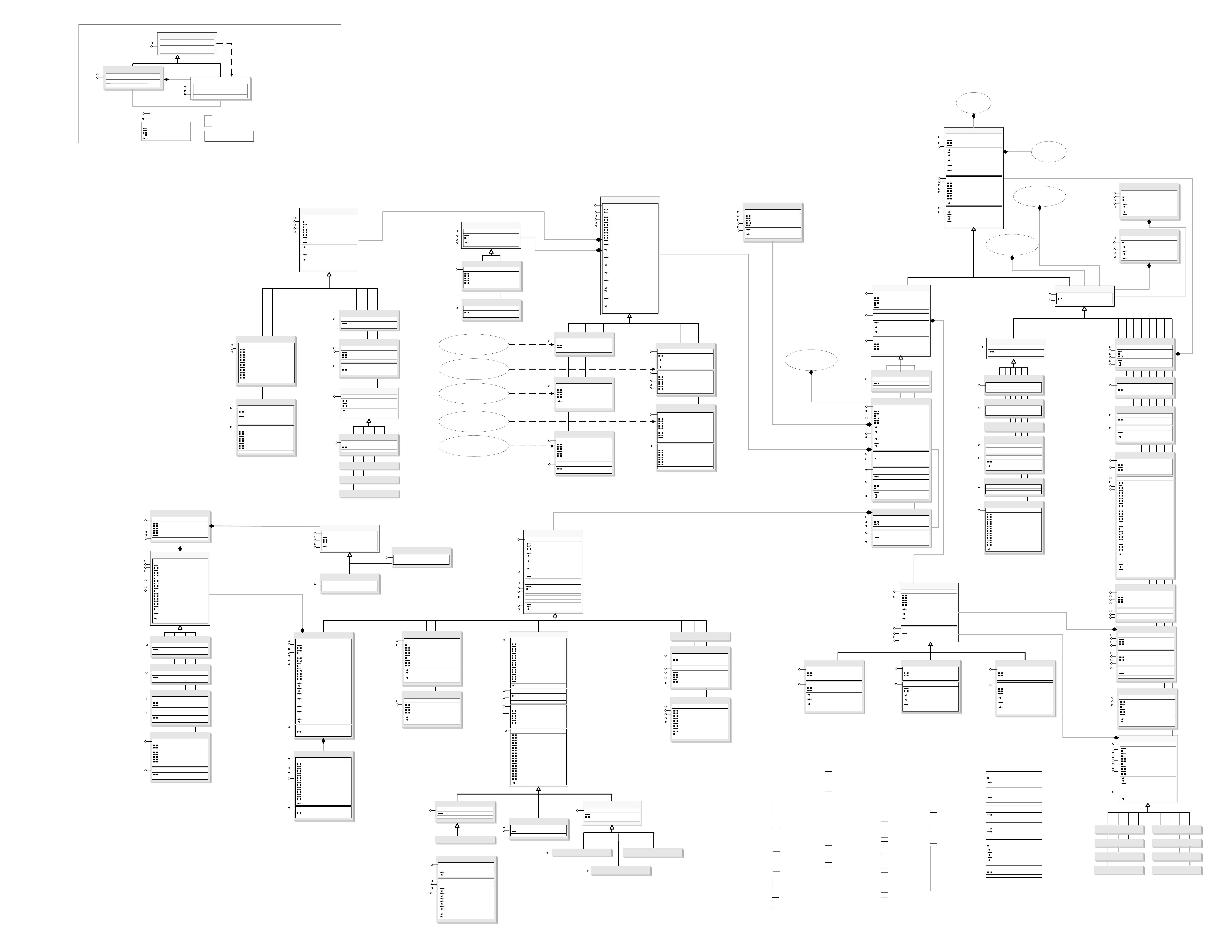
Bookmark3D
IBookmark3D
IPersist
IPersistStream
IBookmarkToKeyframe
IBookmarkToKeyframe : IUnknown
ConvertToKeyframe: IKeyframe
LayerKeyframe
SceneKeyframe
IBookmark3D : IUnknown
Name: String
Apply (in pViewer: ISceneViewer, in bAnimate:
Boolean, in animDuration: Double)
Capture (in pCamera: ICamera)
esriTextureFormatType
1 - esriTextureNone
2 - esriTextureRGBA
3 - esriTextureJPEG
4 - esriTextureDXT
esri3DServerType
0 - esri3DServerScene
1 - esri3DServerGlobe
IBillboardDisplay : IUnknown
BillboardDisplay: Boolean
IBillboardDisplay
CharacterMarker3DSymbol
ICharacterMarker3DSymbol
ICharacterMarker3DSymbol : IMarkerSymbol
CharacterIndex: Long
Font: IFontDisp
VerticalOrientation: Boolean
SimpleMarker3DSymbol
ISimpleMarker3DSymbol
ISimpleMarker3DSymbol : IUnknown
ResolutionQuality: Double
Style: esriSimple3DMarkerStyle
Marker3DSymbol
IMarker3DSymbol
IMarker3DSymbol : IUnknown
IsRestricted: Boolean
MaterialCount: Long
Shape: IGeometry
Thumbnail: IPicture
UseMaterialDraping: Boolean
CreateFromFile (in FileName: String)
RestrictAccessToShape
VRMLExporter
IVRMLExporter : IUnknown
Indentation: Boolean
IsYUp: Boolean
MoveToOrigin: Boolean
Quality: Long
SaveOnlyVisible: Boolean
UseElevationGrid: Boolean
UseGeoVRML: Boolean
IVRMLExporter
SceneVideoExporter
ISceneExporter3d : IUnknown
ExportFileName: String
FileExtension: String
Filter: String
Name: String
ExportScene (in pScene: IScene)
ISceneExporter3d
IVideoExporterProperties : IUnknown
Codec: String
CodecCode: String
CodecCodeList: IStringArray
CodecList: IStringArray
ColorDepth: Integer
DataRate: Long
FrameDuration: Long
IsInstalled: Boolean
KeyFrameRate: Long
Quality: Long
RecordOffScreen: Boolean
RecordWindow: Boolean
ShowSettingsDialog: Boolean
IVideoExporterProperties
AVIExporter
QuickTimeExporter
IAVIExporter : IUnknown
Quality: Long
IAVIExporter
IMapLayers2 : IMapLayers
IsLayerVisibleEx (in Layer: ILayer, out
IsLayerVisible: Boolean, out
isParentLayerVisible: Boolean)
IMapLayers2
IMapLayers : IUnknown
Layer (in Index: Long): ILayer
LayerCount: Long
Layers (in uid: IUID, in recursive: Boolean):
IEnumLayer
AddLayer (in Layer: ILayer)
AddLayers (in Layers: IEnumLayer, in
autoArrange: Boolean)
ClearLayers
DeleteLayer (in Layer: ILayer)
InsertLayer (in pLayer: ILayer, in
autoArrange: Boolean, in position: Long)
InsertLayerInGroup (in pGroup:
IGroupLayer, in pLayer: ILayer, in
autoArrange: Boolean, in position: Long)
InsertLayers (in pLayers: IEnumLayer, in
autoArrange: Boolean, in position: Long)
InsertLayersInGroup (in pGroup:
IGroupLayer, in pLayer: IEnumLayer, in
autoArrange: Boolean, in position: Long)
IsLayerVisible (in Layer: ILayer): Boolean
MoveLayer (in Layer: ILayer, in toIndex:
Long)
MoveLayerEx (in pFromGroup:
IGroupLayer, in pToGroup: IGroupLayer,
in pLayer: ILayer, in newPosition: Long)
IMapLayers
Import3DFile
IImport3DFile
IImport3DFile : IUnknown
CanBrowse: Boolean
FileDescription: String
FileExtension: String
Geometry: IGeometry
IsValidFile (in FilePath: String): Boolean
CreateFromFile (in FilePath: String)
IImport3DApplication : IUnknown
ApplicationGeometry (in pApplication:
Variant, in onlySelected: Boolean):
IGeometry
IsValidApplication (in pApplication: Variant):
Boolean
IImport3DApplication
IImport3DFileRoots : IUnknown
IsValidFile (in FilePath: String): Boolean
RootCountFromFile (in FilePath: String):
Long
RootGeometry (in rootIndex: Long):
IGeometry
ReleaseCurrentFile
IImport3DFileRoots
ExportColladaFile
IExportColladaFile : IUnknown
MultipatchToCollada (in pMultiPatch:
IMultiPatch, in bsFileDirectory: String, in
bsFilename: String, in
bCompressIndexes: Boolean)
IExportColladaFile

剩余75页未读,继续阅读
资源评论


