没有合适的资源?快使用搜索试试~ 我知道了~
蒙古Unkheltseg盆地地质间断的三维地下水流数值模拟-英文版
0 下载量 149 浏览量
2024-05-22
22:04:29
上传
评论
收藏 6.74MB PDF 举报
温馨提示
![preview](https://dl-preview.csdnimg.cn/89342554/0001-4a123368c9cdc1c1284a9028ba37c8a8_thumbnail.jpeg)
![preview-icon](https://csdnimg.cn/release/downloadcmsfe/public/img/scale.ab9e0183.png)
试读
15页
蒙古Unkheltseg盆地地质间断的三维地下水流数值模拟-英文版
资源推荐
资源详情
资源评论
![pdf](https://img-home.csdnimg.cn/images/20210720083512.png)
![rar](https://img-home.csdnimg.cn/images/20210720083606.png)
![pdf](https://img-home.csdnimg.cn/images/20210720083512.png)
![thumb](https://img-home.csdnimg.cn/images/20210720083646.png)
![pdf](https://img-home.csdnimg.cn/images/20210720083512.png)
![rar](https://img-home.csdnimg.cn/images/20210720083606.png)
![zip](https://img-home.csdnimg.cn/images/20210720083736.png)
![7z](https://img-home.csdnimg.cn/images/20210720083312.png)
![zip](https://img-home.csdnimg.cn/images/20210720083736.png)
![pdf](https://img-home.csdnimg.cn/images/20210720083512.png)
![](https://csdnimg.cn/release/download_crawler_static/89342554/bg1.jpg)
ORIGINAL ARTICLE
3-D numerical groundwater flow simulation for geological
discontinuities in the Unkheltseg Basin, Mongolia
Yohannes Yihdego
•
Cara Danis
•
Andrew Paffard
Received: 8 August 2013 / Accepted: 9 September 2014 / Published online: 21 September 2014
Springer-Verlag Berlin Heidelberg 2014
Abstract Groundwater models which realistically repre-
sent the hydrogeology of a complex system, like the
Unkheltseg Basin, are critically important to Mongolia.
They have flow on benefits to research, governments,
management strategies and commercial development
within the country. Limited case studies of calibrated 3-D
numerical transient simulations in fault-controlled con-
nection between basins, similar to the Unkheltseg Basin,
are available in the public domain and the model presented
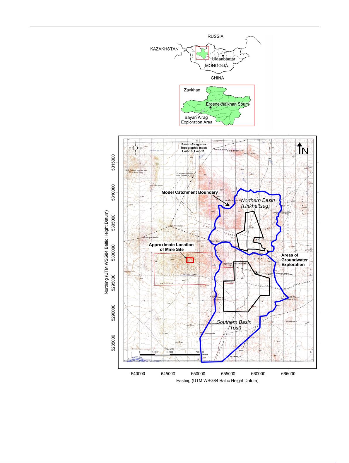
here aims to address this problem. This basin is uniquely
geologically controlled and a key water supply resource for
future economic development in the Taikh Valley. Com-
mercial exploration projects have produced the high-qual-
ity geological and hydrogeological data gathered,
necessary for successful model simulation at a basin-wide
scale. Using the ‘‘DRAIN Package’’ and ‘‘Fracture-Well
Package FW4’’ in MODFLOW-SURFACT, the spatial
discretization necessary to fully represent horizontal and
vertical flow direction was achieved to effectively con-
strain recharge and discharge across the fault barrier. This
model is an important tool for establishing a long-term
monitoring programme in a fault-controlled basin, which
predicts regional impacts, both short and long term.
Keywords Groundwater 3-D numerical modelling
Geological discontinuity Mongolia
Introduction
Groundwater resources play a vital role in Mongolia’s econ-
omy and the industrial and domestic water demand is mainly
met from groundwater sources; about 80 % of the total con-
sumption is from groundwater (Hasiniaina et al. 2010).
Modelling of groundwater resources in Mongolia, which is
also common elsewhere, is challenging, due to limited infor-
mation, both published and government data, historical reli-
ance on simple analytical assessments and complex
geological systems that present limitations to various model-
ling techniques. For effective groundwater management
resource comprehensive and realistic modelling is essential.
Over the past few years, many international companies,
working on projects requiring groundwater supply (Oyu
Tolgi, Energy Resources UHG Coal Mine, Burun Narran Coal
Project), havebegun presenting 3-D numerical simulations for
resource estimation and using these simulations to calculate
resource lifespan and extraction limits, something not possible
with the current analytical methods used in Mongolia.
Over the last few years, a number of discussion papers
have addressed the issue of how models can best serve the
process of decision support. Previous studies (e.g. Gupta
et al. 2012; Kresic and Mikszweski 2014; Nordstrom 2012;
Simmons and Hunt 2012; Voss 2011) have addressed the
extent to which the model’s parameters should be adjusted
to allow it to replicate past system behaviour as a precursor
to its being used in management of future system behaviour
and how complex (or otherwise) it needs to be when used
in this capacity. In this context, a model’s purpose is to
predict the behaviour of a system under a management
regime. Selection of an appropriate level of model com-
plexity is most difficult where predictions required of a
model are only partially constrained by historical data
(Doherty and Simmons 2013).
Y. Yihdego (&) C. Danis A. Paffard
Snowy Mountains Engineering Corporation (SMEC),
Sydney, NSW 2060, Australia
e-mail: yohannesyihdego@gmail.com
123
Environ Earth Sci (2015) 73:4119–4133
DOI 10.1007/s12665-014-3697-4
![](https://csdnimg.cn/release/download_crawler_static/89342554/bg2.jpg)
Faulted aquifers constitute one of the most complex
geological environments for analysis and interpretation of
hydraulic test data because of the inherent ability of faults
to act not only as high transmissive zones but also as
hydraulic barriers (Bense et al. 2013; Bredehoeft 1997;
Cello et al. 2000; Evans et al. 1997; Folch and Mas-Pla
2008; Shan et al. 1995). Whilst our interpretation of the
faulted aquifer remains linear in nature, parameter esti-
mation by numerical simulation highlighted the presence of
hydraulic barriers associated with the faults. These barriers
are readily apparent in the constant discharge test data.
Fracture zones and faults have long been identified as
having significant influence on groundwater flow and
transport because of their contribution to altering the
effective permeability of the aquifer. For this reason, there
have been numerous investigations aimed at describing a
wide range of phenomena, over a range of scales, that are
associated with fractures and faulting (Allen and Michel
1999; Nordqvist et al. 1992; Yihdego and Becht 2013). The
role of groundwater transfers in geological complex terrain
is challenging (e.g. Nelson and Mayo 2014; Yihdego and
Webb 2014). In faulted aquifers, additional complexities
may exist because faults are often observed to act both as
conduits (Huntoon and Lundy 1979; Pimentel and Hamza
2014) and as barriers (Ran et al. 2014; Rojstaczer 1987)to
flow. Thus, broad generalisations regarding the influence of
faults are difficult to make.
The groundwater resource estimation for the basin
region was initially based on yields from pumping tests
(Battumur 2009), interpreted analytically by the Cooper–
Jacob simplification of the this approach (e.g. Freeze and
Cherry 1979; Fetter 1994). This estimation indicated that
there could be sufficient groundwater to supply mining
activities nearby but numerical modelling was required to
confirm and assess the impacts. Snowy Mountains Engi-
neering Corporation (SMEC) was commissioned in 2011 to
undertake a pre-feasibility level study and in 2012 feasi-
bility level groundwater resource assessment, focusing on
the Unkheltseg Basin as a mine water supply source for
Bayan Airag Exploration.
The Unkheltseg Basin
The Unkheltseg Basin is located approximately 930 km
west of the Mongolian capital Ulaanbaatar, 250 km south
of the border with Russia, in Zavkhan province, Erdene-
khairkhan Soum in a region characterised by steep moun-
tainous terrains and wide valleys. The region is dominated
by reverse faults, striking parallel to the mountain ranges,
which have significant vertical displacement, up to 100 m
in some areas. This faulted geometry often disconnects
groundwater aquifers in alluvial systems and there is often
limited or no hydraulic connectivity across the faults. The
basin system appears to be fault block dominated, creating
a basin with steep sides and a relatively flat base which
conceptually looks much like a bath tub (tank reservoir).
The discharge from the basin system into the southern Tost
Basin is controlled by the permeability and hydraulic
conditions of the barrier as groundwater discharge occurs
across a geological discontinuity, which is presumed here
to be a fault uplifted basement. Therefore, there is no direct
hydraulic connection between the basin and the southern
Tost Basin and this groundwater storage–discharge rela-
tionship cannot be easily handled by simple analytical
equations or 1-D or 2-D numerical simulation programmes.
The challenge with 3-D numerical simulations is to pro-
duce a model which realistically simulates natural condi-
tions. Using the ‘‘DRAIN Package’’ and ‘‘Fracture-Well
Package FW4’’ in MODFLOW-SURFACT, the work pre-
sented here shows a successful simulation that correlates
well with the hydrogeological conditions observed.
The model scenario problem
In watershed models, the subsurface-saturated domain is
often represented by a linear, or non-linear, storage–dis-
charge function (e.g. Fiorillo 2011; Kampf and Burges 2007;
Rupp et al. 2009; Singh and Woolhiser 2002; Wenping et al.
2011
). In some cases, the derivation of the function begins
with a physics-based description of saturated flow, but
assumptions made thereafter (e.g. constant head gradient or
successive steady states) lead to a single-valued storage–
discharge function (e.g. TOPMODEL; Beven and Kirkby
1979).These storage–discharge functions are advantageous
in that they are computationally very simple but this repre-
sentation means at the scale of the model element (e.g. sub-
catchment) there is no explicit distribution information in
any spatial dimension (x, y or z) and the model is considered
as zero or one dimensional (e.g. Kampf and Burges 2007).
Models which discretise the groundwater domain in two or
three dimensions and numerically solve the governing partial
equation for saturated flow (e.g. Palma and Bentley 2007;
Singh and Woolhiser 2002; Vandenbohede et al. 2011)do
have the advantage of being spatially explicit. Using a
transient saturated flow model gives analytical solutions to
linear partial differential equations subjected to time-varying
stress, such as recharge or pumping (e.g. Bidwell et al. 2008;
Pulido-Velazquez et al. 2005; Wenping et al. 2011). How-
ever, these solutions can be limited to a homogenous 1-D
representation of an aquifer, which may entail a severe
simplification of the system (Rupp et al. 2009).
A model is a scale-down simplified representation of a
natural system. Therefore, the developments of a model
presuppose the knowledge of the system. The solution to
the problem of how to model the ‘‘tank–reservoir’’ Unk-
heltseg Basin was to utilise 3-D transient and steady-state
4120 Environ Earth Sci (2015) 73:4119–4133
123
![](https://csdnimg.cn/release/download_crawler_static/89342554/bg3.jpg)
models in MODFLOW-SURFACT, which overcome the
drawbacks of the 1-D or 2-D analytical equations, because
spatial information (i.e. hydraulic head) is retained in the
primary and secondary flow directions and the restrictive
assumption that discharge has a one-to-one relationship to
aquifer storage is not made (Sloan 2000).
Fig. 1 Location map of the
study area
Environ Earth Sci (2015) 73:4119–4133 4121
123
剩余14页未读,继续阅读
资源评论
![avatar-default](https://csdnimg.cn/release/downloadcmsfe/public/img/lazyLogo2.1882d7f4.png)
![avatar](https://profile-avatar.csdnimg.cn/cb870bbdd7a340338b08a4ccf0175330_weixin_44259522.jpg!1)
___Y1
- 粉丝: 5105
- 资源: 151
上传资源 快速赚钱
我的内容管理 展开
我的资源 快来上传第一个资源
我的收益
登录查看自己的收益我的积分 登录查看自己的积分
我的C币 登录后查看C币余额
我的收藏
我的下载
下载帮助
![voice](https://csdnimg.cn/release/downloadcmsfe/public/img/voice.245cc511.png)
![center-task](https://csdnimg.cn/release/downloadcmsfe/public/img/center-task.c2eda91a.png)
安全验证
文档复制为VIP权益,开通VIP直接复制
![dialog-icon](https://csdnimg.cn/release/downloadcmsfe/public/img/green-success.6a4acb44.png)